
18 TRICAP
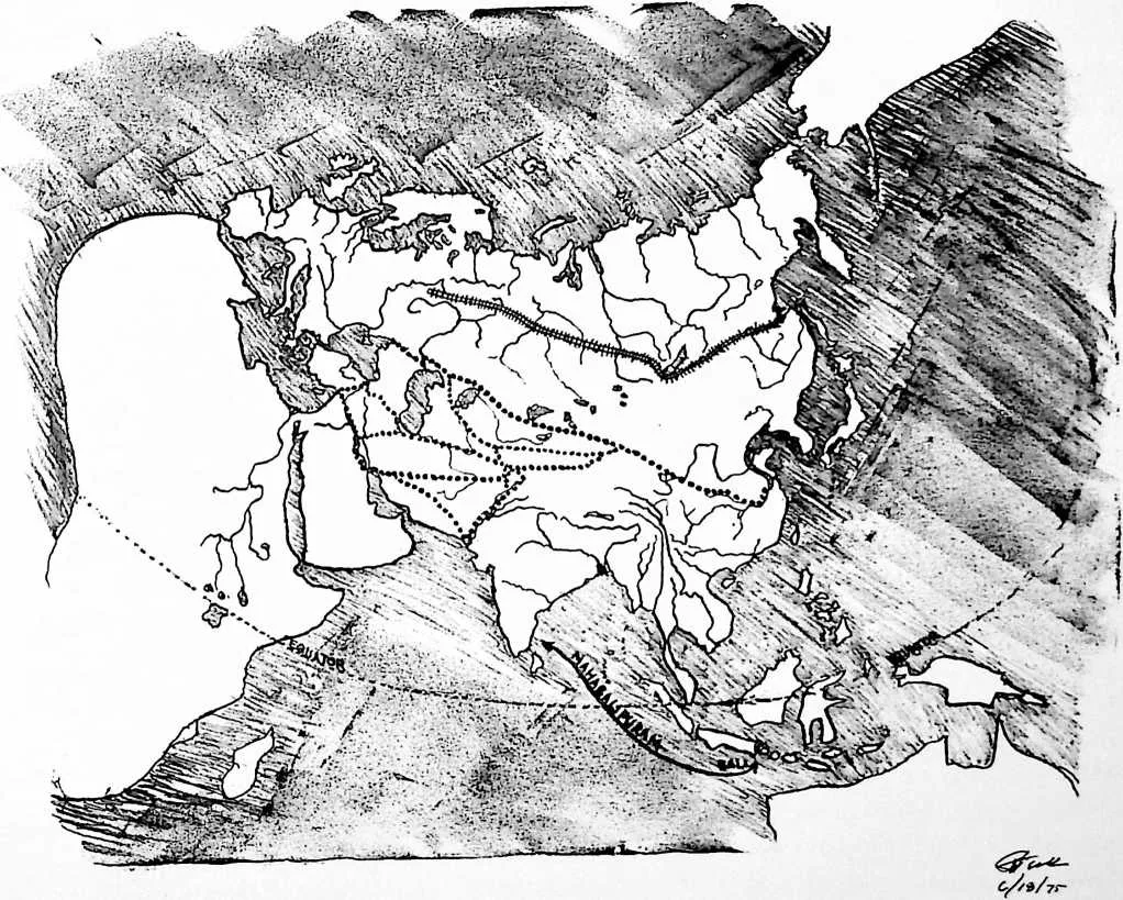
2The Austronesians caught and domesticated mainland animals millions of years ago. Their horsemen hunters penetrated inland earliest and fastest, reaching Europe, dwelling and painting in caves wherein they bleached out during the last Ice Age. In the subsequent Stone Age these horsemen built strategic citadels, exploited the herders and the fruit, nut, leaves, and root gatherers. Goldy now draws a map for the Three Bears showing the horsemen’s multimillennia-earlier five east-to-west caravaning routes and how the evolving Indian Ocean ships could more swiftly carry much larger cargoes than caravans and how, despite the religiously biased way in which the priests and scribes chose to write Eurasian history, all of its military struggles were waged between empires secretly puppeted by the grand masters of the alternate east-west overland and water routes. Thus was Emperor Constantine puppeted into shifting Roman Empire headquarters to command the Bosphorus and reestablish the overland route. Seeking to reestablish the water route the ‘‘Holy Grail’’ drive of the ‘‘Crusaders’’ sought to wrest overland access to the Indian Ocean from the Moslem Saracens. After 4,000 years of struggling all Near-Easttransiting trade was mothballed when Henry ‘‘The Navigator’’ of Portugal inaugurated sailing from Europe to the Orient via the Atlantic around Africa. Thereafter, a succession of world-ocean masteries culminated in the East India company’s ‘‘British Empire’’-puppeted supremacy over all the world’s oceanic trade routes. This oceanic mastery suddenly terminated in World War II, when the line-of-supply control shifted into the air and is now shifting again into the airless ocean of outer nothingness, intervening relativity’s cosmic events.
3 STONE 17
5 These horse and camel people became the first to travel back and forth along their most favorable routes between what became known in later European history as the Far East and the Near East. The Dravidian inhabitation of the southern coasts of India represented the second westward continental landing and settlement of the Austronesians, which settlements then served as basing points for much farther westward water venturing. The Luxor Egyptians constitute the second successful westward jump of waterborne civilization which maintained via East Africa its trade with the trans-Indian Ocean merchant ships. From the walls of the Egyptian navigator-priests’ tombs we learn of their maritime technology history. So also from the walls of their Southern Europe caves we first learn of the Mediterranean presence of the millions-of-years-earlier-arrived horsemen hunters, who only 4,000 years ago came to invade the Egyptian Empire and its trans-Mesopotamian water world traders, whose presence appeared to the northern Mediterranean horsemen as a threat to their many-millennia-earlier monopolization by caravan of all the Far-East-Near-East trade. On the other hand the Egyptians considered themselves to be the most civilized of known people and technically very advanced because their Indian-Ocean-crossing ships could carry much larger cargoes than could be carried by human bearers or animals on the northerly overland routes and could cover the distance between the Far and Near East so much faster; the Egyptians looked upon the northern horsemen as hordes of wild barbarians. Obviously this provoked the northern ‘‘barbarian’’ horsemen, in this case the Hittites, into invading and eventually overwhelming the Egyptians. Thus began a series of historical strugglings of north vs. south---of the overland vs. waterborne east-west tradesmen. These wars were waged through their puppeteered monarchs and were always waged for some propaganda-invented ‘‘religious causes.’’ Century after century, millennium after millennium, new great empires were established first by the power of the northern overlanders and next by that of the southern overseas, Orient-to-Europe exploiters. In the successively westward ‘‘nouveau riche’’ Near East and later European worlds the traders from the Orient ‘‘cashed in’’ on the thousands of years of earlier discovered and developed art, artifacts, and ‘‘riches’’ of Oriental civilization. The Mongol horsemen from the Black Sea and Caspian country rode south and west of the Himalayan range to invade India going eastward and northward along the Indus River and thence eastward again south of the Himalayas to cross the continental wastershed divide to reach the south and eastwardly flowing Ganges, along which they met the Austronesian water people who had traveled inland from the Bay of Bengal via the Ganges. The Mongol horsemen vanquished the on-foot, Indian-Ocean-landed Dravidians and founded the Mohenjo-Daro civilization.
6 Time after time the Mongol (Moguls) invaded India overland to completely master the lives of India’s many-thousands- (possibly millions) -of-years-earlier-landed maritime coastal settlers, whose much earlier presence as yet remains to confound humanity by its two great (probably) Dravidian legacies---Mahabalipuram, meaning ‘‘the big Balinese (type) city’’ on India’s southeast coast, and Elephanta on the northwest coast. Each of these are monolithic carvings reduced in place from one whole solid rock the size of a small mountain.
7 Elephanta, on an island in the harbor of Bombay, is a whole temple entered through an ornately sculptured rectilinear opening in the side of the mountaintop within which the interior of the mountain sculptured temple is complete with elegantly capped and pedestaled interior columns integral to the whole stone fashioning of the vast hand-sculpted cave temple, along each of whose interior walls are arranged heroic scale sculptures of the Vishnu-Siva- Brahma Trimurti (Trinity); while Mahabalipuram south of Madras on the east coast is one whole mountainous rock reduced in place to all the external surfaces of a monolithic temple surrounded by an array of the same monolithic carvings of life-size or heroic sculptures of realistically rendered elephants and other animals, while all the temple---its columns and interior sculptures of Vishnu-Siva, including much delicate and intricate roof-edge carving, including independent cut-stone chain links---is all integrally carved in place out of the one original solid-rock hill.
8 Mahabalipuram is an overall positive, convex, male conception, and Elephanta is a negative, concave, female enclosure conception with a positively sculptured interior. Despite hundreds of intervening miles Elephanta and Mahabalipuram are as inseparable---conceptually, philosophically, and stylistically---as are the coexisting concave and convex surfaces of a tennis ball. Most astonishing about these two, in contrast to the many later-era cave sculpturings of Buddhist monks in India, is that both Mahabalipuram and Elephanta appear to have been designed and executed by one sculptor in one day, so coherent and consistent is their rendering, whereas each must have taken hundreds if not thousands of years and many, many generations to accomplish. That so many people over so many generations could have seen so ‘‘eye to eye’’ with one another and maintained that comprehending coordination transcends any comprehension by humans of our era. It manifests how little change has taken place in millions of years in the way of the sea with humans and manifests the simple integrity of understanding of these half-a-planet-occupying Austronesian water people whose outrigger canoes sailed at twenty knots from their millions-of-years-ago inception---a speed never since exceeded by sailing craft---a people who speak only one basic language, who invented mathematics and the calculating machine, for the rings on their fingers, wrists, and necks were the forerunners of the abacus, the only kind of calculating machine suitable to a frequently wave- and rain-drenched naked people---who eons ago came out onto the subcontinent of India, Sri Lanka, and Madagascar from the smaller atolls of Austronesia just as they had somewhat earlier come out from the larger islands off the coast of Indochina and Malaysia, Java,
9 Sumatra, Burma, et al. This atoll-to-mainland transition covered millions of years and includes the three-and-one-half-million-years-ago Leakeys’ humans, who landed on the northeast coast of Africa.
10 So much more powerful in combat on the land than the on-foot Austronesians were the horse-mounted Mongols who rode into northern India that they gradually pushed the Austronesian Dravidians into the southeast tongue of India and the present-day Sri Lanka.
11 Goldy now draws a map for the Three Bears showing the original most northerly route and its subsequently established competitors’ alternate, overland, horsemen-blazed, caravan routes from China to the Mediterranean shores. Despite the biased way in which the priests and their scribes of the various empires chose to write history, practically all of its military struggles were waged through their puppet empires by the respective behind-the-scenes grand masters of commerce of the several successively o’erwhelming alternate overland and alternate water routes between the Orient and Occident. The succession of the all-Asia-Minor empires, starting with the Moguls’ invasion of India and their founding of the Mohenjo-Duro period, went as follows: Chaldean, 3800 b.c.; Elamitic, 2000 b.c.; Egyptian, 1600 b.c.; Hittite, 1200 b.c.; Assyrian, 670--645 Ib.g.; Babylonian, 600 b.c.; Median, 600 b.c.; Persian, 500 b.c.; Greek Alexandrian, 323 b.c.; Roman 0--117 a.d.
12 Jerusalem (Urusalem) is situated approximately halfway between the dominantly northerly and the dominantly southerly routes and, in marked contrast to its name---Uru (city) Salem (peace)---has been successively captured and recaptured by the successive winners of the struggles for command of the wealth of exploitation in the west of the riches of the east, whose successive masters undertook to establish their own grandeur and augment their power by inventing the concept that the beginnings of human life occurred within their domains and when in combat with others proclaimed that they were the exclusive favorite of their one or more gods and that they had divine commission. The successive invisible grand masters of the ten east-west trade routes were the wealth-manipulating brains behind the successive empires encompassing all of Asia Minor. The ten successively dominant alternate east-west trade routes consisted of six which used rivers and lakes but were predominantly overland and four which crossed some dry land but were at least nine-tenths by water. All six of the overland routes went from Hankow on the Yangtse River, at whose mouth was Shanghai, and led from Hankow northwesterly to Lanchow, Kanchow, and Suchow to Sinkiang, whereafter they branched three ways, route 1 via Alma-Alta, the second route via Samarkand, and routes 3, 4, 5, and 6 via Kabul. Routes 1 and 2 run north of the Caspian into the Sea of Azov and there by water through the Bosphorus into the Aegean and Mediterranean seas.
13 Routes 3 and 4 ran from Sinkiang via the Khyber Pass and Kabul to skirt south of the Caspian and thereafter split into two more routes, one to the south shore of the Black Sea and thence to Tarsus on the northeastern corner of the Mediterranean, just northeast of Cyprus; while the other branched from the first where Tehran is now situated, ran southwest to the Euphrates, then northwest to Damascus and finally Tarsus. Routes 5 and 6 ran from Sinkiang through the Khyber Pass via Kashmir, whereafter route 5 ran via Babylon to Baghdad, Damascus, and Tarsus, and route 6 down the Indus River to where Karachi is now situated and thence overland to Babylon, Baghdad, Damascus, and Tarsus.
14 Route 7, the first of the four water routes from China and Indochina and India, was sailed and rowed via the Persian Gulf to Baghdad, thence up the Euphrates, thence overland to the Mediterranean. Route 8 ran via the Red Sea and Gulf of Aqaba to the Levantine coast, route 9 via the Red Sea to Suez and overland to the Nile delta, and route 10 via the Red Sea to a point closest to Luxor and overland to that early Egyptian capital, thence north on the Nile to the Mediterranean. Those ten routes resolve themselves into three most intercompetitive subgroups: the two northerly can be called the northerly group; the five routes all leading to Tarsus (four overland and one by water to Baghdad) can be called the middle group; and the three Red Sea routes can be called the early southerly group---but the route from the Red Sea to Gulf of Aqaba and thence overland to Jericho, Lebanon, and other Levantine coast ports forsook the southerly group and became a contestant for dominance of the middle group.
15 All of these early empires have their own complex of gods representing dominant attributes for life-giving, -managing, and -terminating functions. As with the early water people it was assumed that the gods were not concerned with the people but only with the temporal monarch, and that concern was only to secure the king a place among the gods. With a few millennia of development and proliferation of technological know-how, tools, physical materials, and building capability it was realized that in addition to equipping the monarch for safe passage into the afterlife, it would be feasible to assist all the nobles in safely reaching the next world, which was done by preparation of elaborate tombs in which were secreted all the riches, foods, and tools that the king (and later nobles) would need in the next life. As millennia passed so much know-how was accumulated that during the last millennium b.c. it became technologically feasible to prepare elaborate mausoleums to enable the rich middle class to migrate into the other world. Finally it became technically feasible to prepare all of humanity for entering into the afterlife. This occurred at year zero, when the southerly group came into command control of the east-west trade.