
10 Searching for Perspective
2One of the issues Fuller focused on following the termination of Dymaxion Deployment Unit production was the problem of accurately displaying the entire Earth on a single map. He had been surveying that issue for years and had published some interpretations of global resource usage and distribution on rudimentary ‘‘Dymaxion Maps’’; however, he had yet to perfect his idea.1
3 Bucky’s concept of displaying the entire Planet on a single practicable-sized sheet was by no means new. Human curiosity has always motivated people to learn as much as possible about their environment and in particular their immediate surroundings, but for most of human existence, that nearby environment had amounted to the distance an individual could walk. . .
4 By examining history, Fuller found that people s range o p YS1C environment was continually expanding to include more territory as eir knowledge grew. He also discovered that once human beings determined the Earth was spherical, individuals promptly began searching for satis y ing methods of viewing the entire Planet.2
5 Maps flourished, but mapmakers discovered enormous problems in attempting to transfer even limited information from a sphere to a a surface. The primary problem they encountered can be demonstrate y peeling an orange and flattening the skin, invariably tearing muc o t e peel’s surface. Similarly, in the process of shifting from globe to at map, splits occur.3 Those breaks represent distorted data, an unsolve pro em which has plagued humanity for centuries.
6 With the onset of easily accessible worldwide communication and transportation, most people’s primary environment has expanded to in-clude all of what Fuller later referred to as Spaceship Earth, and Fuller found that the innate curiosity of a majority of individuals had burgeoned in a similar manner.4 Since scientists and explorers have determined the Earth to be spherical, that curiosity has generally been satisfied by accu-rate globes, which do not embody the extreme distortion inherent in most flat maps.
7 Globes are precise because they are spherical like the Earth itself, but that very characteristic limits their usefulness. Because of the spherical shape of a globe, an individual can examine only a portion of the Earth’s surface at one time, and such a limited perspective does not promote understanding of the true relationships inherent on our Planet.
8 Fuller had learned a great deal about maps and the Earth in general from his extensive naval experience, both in the military and as a civilian. Because their livelihood and lives depend on navigating without the land-marks available on dry land, sailors have always demanded the best navigational tools, and accurate maps are one of the most important such tools.
9 For centuries, maritime societies have been confronted by and have seriously examined the problems inherent in mapping a spherical surface upon a flat surface such as a piece of paper. More recently, modem technology has been applied to that problem in an effort to depict the spherical Earth in a manner suitable for maritime navigation. Bucky found that engineers and mathematicians who had no knowledge of sailing even went so far as to propose using globes for marine navigation. Such a notion amused pragmatic sailors, who understood that a globe containing enough detail to be of any use in navigation would have to be much larger than the largest ship at sea.5
10 Because of his knowledge of and experience with both mathematics and the sea, Bucky was able to examine the problem from the more realistic stance of a sailor. He understood that modem sailors rely on two types of maps: comprehensive ones displaying large portions of the Earth and more precise sectional charts of specific areas which provide great detail and are the primary instruments of navigation.6
11 In his quest for a better map, Fuller studied the history of marine navigation and found that sailors had attempted to employ the same Mer-cator map of Earth (which was developed in the 16th century and which continues to be displayed and used in most schools and institutions) for navigation. Those sailors discovered that map to be adequate in many instances, but they ultimately established that their success was due to the travel routes they used rather than the accuracy of the maps.
12 Sailors found that the Mercator map worked well because they sailed primarily in the warmer, less hazardous waters near the equator, where the Mercator map exhibited the least distortion. Their Mercator projection maps, however, became less and less accurate as they ventured further from the equator because a Mercator map, like most other maps, is gener-ated by mechanically projecting the Earth’s features from a globe to a sheet of paper.7
13 In the instance of the familiar Mercator map, the paper which will become the map is initially rolled into a cylinder that touches an Earth globe at the equator. The Mercator projection technique can be envisioned by imagining a single light bulb at the center of a clear globe which has the Earth’s landmasses etched upon it. The cylinder of paper is then posi-tioned to touch the globe only at the equator, and, when the central light is turned on, a shadow is projected onto the paper. Tracing that shadow on the paper creates a classic Mercator map projection.
14 Because the equator circle and the paper are in direct contact, that line touches the globe and contains no shadow distortion.8 However, just as the size of a shadow increases and its clarity decreases with increasing distance from a light source, greater distortion occurs as the map shadow is projected farther from the equator.
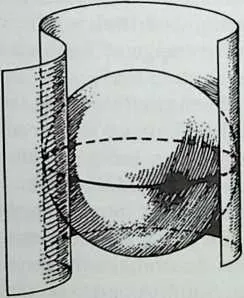
16 Fig. 10-1 The Mercator map projection method. A flat sheet of paper is wrapped globe (left), and no distortion occurs only on the equator line, which runs own sheet when it is laid flat (right).
17 The problem with such a technique is extremely evident near the poles, where the shadow expands to such an extent that the exact North and South Poles cannot be projected onto a paper cylinder of any size. That phenomenon is the result of the fact that light passing through the globe’s two poles travels parallel to the cylinder of paper and, conse-quently, never comes into contact with it.
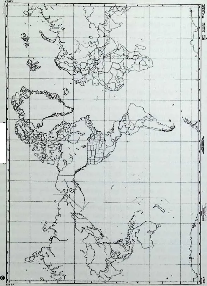
18 By studying mapping techniques, Fuller found that mapmakers had historically redrawn the highly distorted areas of the Mercator map to compensate for the gross inaccuracies farther from the equator and to produce a more acceptable representation. Because those alterations tend to be aesthetic rather than mathematically calculated, such work was seldom precise and continued to promote a grossly distorted view of Earth.9
19 For example, on the redrawn, commonly used version of the Mer-cator map, Greenland is displayed as three times the size of South Amer-ica when South America is actually three times the size of Greenland. Still, with no better alternatives, people have accepted and utilized the warped Mercator representation of Earth for centuries.
20 In his examination of cartographic history, Fuller found that, like most knowledge, humanity’s quest for a true graphic representation of Earth developed gradually as each generation expanded on the work of its ancestors. He also discovered that during the twentieth century the search for more accurate representations of Earth escalated dramatically.10 With-in the past few decades, researchers examined thousands of possibilities in an effort to uncover a better method of transferring data from a spherical globe to a flat surface and bringing integrity to the image of Earth we all share.
21 Because the majority of human beings have been conditioned to think of the Earth as the static object represented by the Mercator map seen in classrooms, popular opinion holds that the new maps being produced, which frequently appear very different from traditional Mercator maps, are novelty items. Although some people find such maps interesting, few believe that those unconventional representations portray a true image. After all, how valid could a map be which depicts Australia in the form of an elongated kidney bean three times longer than South America or which depicts entire continents as seeming to have been stretched from their most northerly and southerly points?
22 When Fuller first became an explorative cartographer seeking an accurate global perspective during his 1927 period of solitude, his motives were not academic as was true of so many other investigators.11 Instead, Bucky initiated his quest as a means of helping bring attention to and solving worldwide problems at a time when few people considered, much less sought, answers to global issues.
23 He believed that the emerging globally oriented society would be confronted with serious problems that could be resolved, or at least lim-ited in intensity, by an accurate World map and that perpetual exposure to misleading World maps, as has been the case throughout history, only complicates and discourages such solutions. As a result of that conviction, Fuller set out to examine the World map problem and to provide the best solution possible.12 That quest continued throughout his life, and it pro-duced some uniquely comprehensive inventions as well as options to significant yet often unconsidered issues of our emerging global society.
24 One such issue was technology’s influence on military combat. With the advent of modem aircraft and bombing techniques, humans have witnessed entire cities being demolished in a matter of hours or minutes. People are also aware of the fact that intercontinental nuclear missiles provide an opportunity for destruction far beyond the scope of anything previously known. However, our perception of that massive capacity for devastation is frequently concealed by conventional World maps, which portray ‘‘the enemy’’ as situated a great distance from ‘‘us.’’ Such maps conflict with most people’s individual experience of a ‘‘shrinking’’ Earth on which human beings feel they are moving closer to one another as they learn more about the people and cultures of lands previously considered distant.
25 Fuller felt that every human being could trust the single attribute which has always provided individuals with an authentic perspective and could be applied to the issue of war. That characteristic is an individual’s personal experience, and it has guided many people to understand that ‘‘the enemy’’ is, in reality, much closer than institutions lead us to believe or than children are taught in school.13
26 Increasingly rapid air transportation and communication has moved every citizen of Spaceship Earth nearer to his or her neighbors, regardless of the countries involved. Fuller believed that displaying the true physical relationships between landmasses, nations, and individual human beings on a map would promote a much more honest impression of the human condition on Earth at this time.14 He also felt that such a view could provide individuals with a new perspective of ‘‘the enemy.’’15
27 Fuller realized that once individuals begin to recognize their true relationship to tiny Spaceship Earth and the other inhabitants of our Planet, the issue of an enemy’s position would lose its significance. He felt that people who are provided with a trustworthy perspective of Earth on a regular basis would begin questioning the validity of labeling human beings living at distant sites or adhering to other religions or forms of government as ‘‘the enemy.’’16
28 A comprehensive global perspective supplies each individual with an opportunity to personally experience and understand, as Fuller did, that all the inhabitants of Spaceship Earth form a single aggregation living on the small segment of our Planet’s land which is inhabitable. When the facts that all the land on Earth covers less than one third of its surface and that 90 percent of the human population lives north of the equator are por-trayed on an undistorted World map, an individual can begin to com-prehend the tightly packed nature of humankind’s living arrangement.17 Within such a context, destroying a neighbor’s resources is more easily appreciated as the destruction of one’s own life support.
29 Early in his mission on behalf of all humanity, Fuller realized that the global scope of his operation necessitated graphically portraying World data such as population and resources. His first attempt at such a display was presented on a standard Mercator map, but he quickly discovered that the map itself transformed information into misinformation.
30 Bucky often commented that his frustration with ordinary maps was analogous to an individual’s seriously examining him or herself in an extremely warped mirror. Although such mirrors entertain us at amuse-ment parks, when a person needs to be certain he or she looks just right for an important meeting, a severely deformed mirror becomes a real problem.18
3132Fuller’s attempts to deploy his precise global data on an ordinary map were monumental failures, but they provided him with valuable learning experiences. Following those episodes, he understood that even the most reliable information would be deformed and misrepresented by a distorted map, just as a person’s image is distorted by a warped mirror. Those experiences did not hinder his examination of World issues, but in each instance of portraying global data on ordinary maps, his presentation was marred by a lengthy explanation of the problems inherent in the maps he used. Growing frustration led Bucky to realize that emerging global hu-manity needed a map with no visible distortion, and time and time again he was spurred to satisfy that requirement.19
33One of the initial tasks he undertook in studying maps and searching for a superior World map was to painstakingly produce detailed freehand drawings of the entire Planet. Although that job was laborious and time-consuming, it provided him with a global familiarity and appreciation experienced by few other people.20 His intimate knowledge would later prove to be extremely beneficial on numerous occasions, not the least of which was during the years he spent perfecting the Dy maxion Map.
34 Through his studies, Fuller determined that despite the absence of undistorted World maps, our innate curiosity and technology have created a unique modem appreciation of geographic, and consequently human, relationships.21 For instance, individuals are beginning to understand that the shortest distance between two points on the Earth is represented by the arc of a great circle (i.e., the largest circle which can be inscribed on the surface of a sphere) rather than a straight line drawn on conventional maps.
35 That phenomenon can be observed by plotting a course between New York and Paris on a traditional World map and then on a globe. The difference between those two routes clearly demonstrates the problems inherent in traditional global maps.
36 Bucky felt that if individuals studied the more comprehensive field of spherical geometry before they studied limited plane geometry, they might notice a relationship between their classroom studies and the reality of modem travel---including the possible travel of destructive interconti-nental missiles.22
37 During his later years, he was pleased to witness that, as a result of humanity’s need to comprehend our spherical Planet, spherical geometry (and specifically the concept of great circles) was entering the realm of common knowledge. The most conspicuous example of a great circle is the Earth’s equator, but the number of possible great circles on any sphere is infinite. In essence, the arc of any great circle is analogous to a straight line on a flat surface because it is the shortest surface distance between any two points on a sphere.
38 Knowledge of great circles and spherical geometry has historically remained within the domain of scientists and mathematicians. It was considered interesting but seldom relevant to ‘‘practical’’ matters for most of human history when an individual’s maximum daily travel was re-stricted to the speed of a pack animal and the shortest distance between two points was usually a visual ‘‘straight line.’’
39 With the advent of air travel, however, the entire Earth has become a single transit system, and its natural barriers are of little concern to most travelers. Consequently, the ‘‘as-the-crow-flies’’ technique of navigation,
41 CHART OF THE WORLD
42 Fig. 10-2 A standard Mercator map published by the United States government.
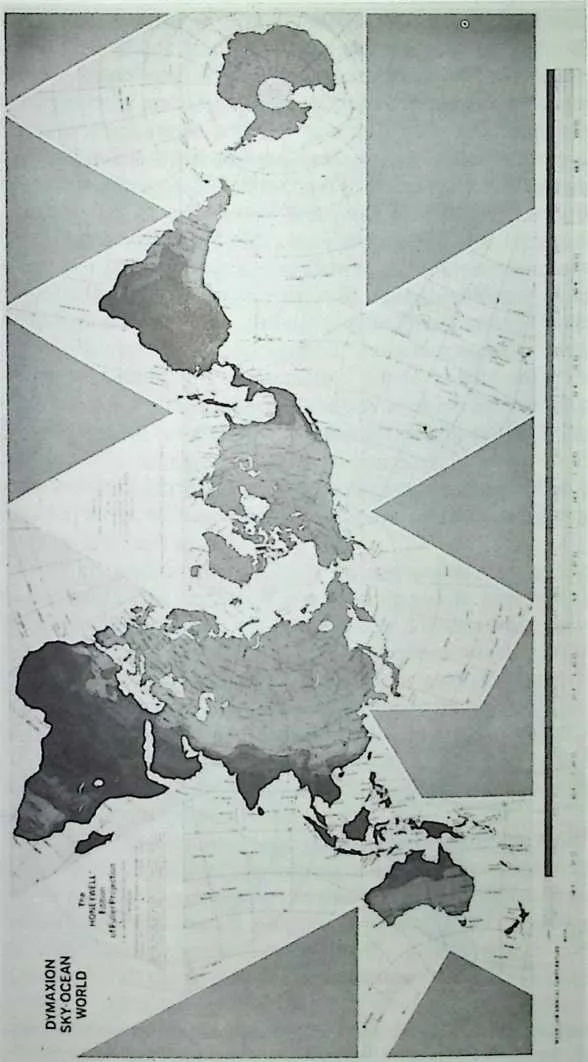
44 Fig. 10-3 The Dymaxion Map in its most familiar configuration. Note the difference in the size and the relationship of the landmasses when displayed with minimal distortion.
45 which relies upon great circles whenever large distances are involved, has become extremely important.
46 By understanding great circles and being exposed to ever more so-phisticated displays of information, today’s globally oriented individuals are beginning to be more aware of the major distortions inherent in nearly every large map. Fuller first discovered those same distortions in the 1920s. The most conspicuous of them appears in the Southern Hemi-sphere, where the entire continent of Antarctica is frequently eliminated or is portrayed as a jagged fringe along the lower edge of the map.
47 A century ago, when it was believed that the northern and southern polar areas were merely blanketed with masses of floating ice and when Antarctica was unexplored, such distortion was insignificant. However, modem technology has drastically altered the significance of that seem-ingly innocent misrepresentation. Today when a great deal of human activity affects the totality of the Earth and its inhabitants, as witnessed in the recently discovered hole in the ozone layer over the Antarctic re-gion and fallout from nuclear accidents, we can no longer afford such deceptions.
4849Early in his experiment to determine what one individual could ac-complish on behalf of all humans, Bucky realized that as people expanded their exploration and influence into every area of the Planet, humanity could no longer relegate any location to an insignificant status. Yet, he found that the maps which greatly influence people in creating their per-sonal interpretations of Earth---including the relationships between land-masses, nations, resources, and individual human beings---continued to grossly distort many areas.23 Frequently, such maps even lend credence to the erroneous belief that the misrepresented areas are not important or are so far removed that they are irrelevant to the daily life of most people.24
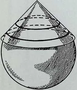
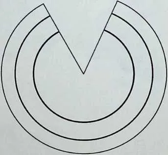
51 Fig. 10-4 The polyconic projection method. Paper is positioned so that two circular lines touch the globe (left), creating two lines of no distortion when the paper is laid flat (right).
52 Fuller felt that such maps thoroughly alter the truth and consequently influence all global activities, including news and education. He also believed that the emerging global human required an accurate, undistorted representation of our relatively small Planet so that individuals could formulate accurate decisions beneficial to all humankind.25 The Dymax-ion Map provided that representation.
53 Before even attempting to develop his new map, Fuller devoted a great deal of time to studying mapping techniques and discovering the weaknesses and strengths inherent within each of them. Because distor-tion is intrinsic in any transfer of information from a spherical (i.e., globe) to flat (i.e., map) surface, Fuller found it to be the critical problem in the creation of a World map.26
54 Since all traditional processes of conversion require that the globe touch the map’s flat surface at one or more points, that point or series of points on a map contains no distortion. The Mercator map provided Fuller with a classic example of the distortion pattern which occurs in all me-chanical map projections. More deformities always appear the farther a site is located from the point or points of contact between the sphere and the flat surface, and because the handful of methods employed in the manufacture of most maps all utilize a similar projection procedure, each of them generates a similar pattern of misrepresentation radiating from that point or points of contact.
55 Although the Mercator map projection is by far the most commonly used, maps which require greater accuracy are generated by a technique known as poly conic projection. In that method, a shadow image of land-masses is projected from a globe onto a cone rather than a cylinder of paper, and because the cone intersects the globe twice, it creates both a large and a small circle where no distortion occurs. The polyconic map projection is most advantageous when accuracy over a specific area is necessary because the tract between the two circles of intersection is far less deformed than the remainder of the map.
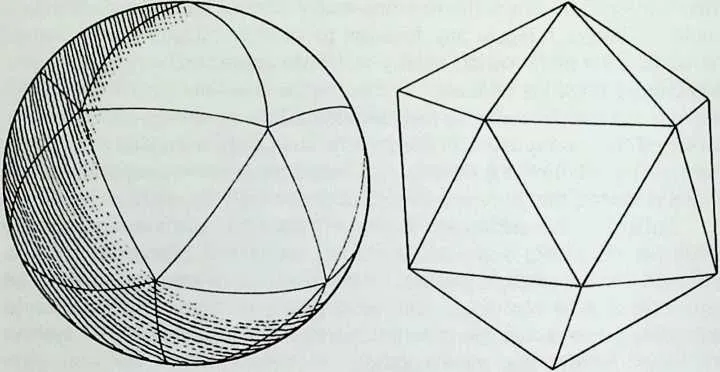
5758Fig. 10-5 The Dymaxion projection method. A spherical icosahedron (left) is inscribed upon a World globe which is then transformed into a planar icosahedron (right). That planar icosahedron is then cut along its edges to create the Map.
59 Polyconic projections reduced deformities more than any other pro-jection technique prior to Fuller’s invention of the Dymaxion Map. The uniqueness of the Dymaxion Map lies in its lack of visible distortion. In fact, the Dymaxion Map is the first and only map which provides a view of the entire Earth’s geography with no visible distortion in shape or relative size of continental masses and no fabricated rifts in those land-masses.27 With Fuller’s Map, the entire surface of our Planet can be perceived as what he christened a ‘‘One-World Island in a One-World Ocean.’’28
60 That view is the direct result of Fuller’s patented system of map production. Rather than relying on traditional shadow projection tech-niques with their inevitable distortion, Bucky applied his knowledge of mathematics to developing and fabricating the Map, creating it by mathe-matically transferring data from a spherical globe to a flat map surface.29 Although many people today would find such a task rigorous but not impossible with the assistance of computers, Bucky confronted the job in the 1920s and 1930s without even a calculator, and he was forced to make all his calculations manually.30
61 Because of his explorations of spherical and plane geometry, Fuller understood that even if done with total accuracy, such a transformation would still produce some distortion, but he felt that if he relegated that minor distortion to the three quarters of the Earth covered by water, it would not be apparent or meaningful.31 He also determined that because his method---like the Mercator technique, which produces no distortion along the equator---would produce no deformities along the edges of the structure, he would be most effective if he employed a geometric form that provided a maximum number of regular sides (i.e., identical in length) to transfer data.32
62 Fuller found that the single structure which best suited his needs was a regular icosahedron, composed of twenty equilateral triangles. And after years of experimentation, he devised a mathematical method of transform-ing a regular spherical icosahedron into a regular plane icosahedron in order to reproduce the spherical information accurately on a flat surface.33
63 A spherical icosahedron is simply an icosahedron in which the edges have been curved to such a degree that the structure is spherical rather than planar. It can be visualized as a volleyball which is constructed of three-sided, regular (i.e., equilateral) triangles rather than five-sided regular pentagons.
64 Fuller’s transformation can be visualized as removing just enough o the triangulated volleyball’s air so that the arcs of the triangles can be straightened out, thereby creating a planar icosahedron. That structure contains edges identical in length to the arcs of the arcs in the spherical version, but the inner areas of the triangles are flattened and thereby produce a structure which can be ‘‘cut apart’’ along any of its edges to produce a flat map.
65 As those arcs are transmuted into straight lines, the areas within the triangles shift slightly inward creating a small amount of distortion, but the arcs themselves, which become the edges of the Dymaxion Map triangles, remain intact. If the distance between two locations situated on one arc is two thousand miles on the globe, it remains exactly two thou-sand miles on the Dymaxion Map.
66 To further reduce deformities, Fuller dissected each of the twenty large triangles into smaller triangles and performed the same process on t e smaller shapes. And by repeating that procedure on an ever smaller sc e, he was able to create a Map in which the distortion is so minute and even y spread among all the landmasses that it cannot be detected by the human eye.34
67 The fact that Fuller’s methodology altered shapes inwardly and re-duced them in size rather than expanding them is also crucial.35 Defor-mities cannot be avoided when one is transforming data from spherical to planar surfaces. However, just as the enlargement of a photograph pro-duces a much greater distortion than its reduction, so projecting an image outward, as is the case with map projections, creates much greater distor-tion than transforming it inward in a reduction process, as is the case with the Dy maxion Map transformation.
68 Once he had determined a method of transformation, Fuller was confronted with the problem of how to position his spherical icosahedron so that after the transformation to a planar structure he could cut the structure apart without creating unnatural breaks in the surface of any landmasses. Because he sought to display the Earth with no map-generated breaks in continents and an accurate representation of the relationship between land-masses, Bucky again initiated a system of patient trial-and-error experimen-tation to determine the best configuration.36 That procedure escalated into a two-year process of methodically turning and examining a World globe encased within a spherical icosahedron grid representing the triangles of the evolving Dymaxion Map.37
69 Eventually, Fuller did uncover the configuration now recognized as the Dymaxion Map. Upon close inspection of that Map, the difficulty of his task becomes apparent.
70 For example, on the eastern coast of both South America and China and on the western coast of Australia, the edges of the triangular sections come extremely close to the landmasses. Another instance of his careful work can be seen in the area surrounding the continent of Africa, which is positioned very near the edges of the triangles that constitute the outer border of the Map.
71 Fuller’s patented method of inward map transformation can be lik-ened to his work with geodesic domes because in both instances he relied on the same geometric principles and mathematical knowledge. However, when developing the geodesic dome, Fuller projected outward from the icosahedron to the sphere, and when developing the Dymaxion Map, he projected inward from the sphere to the basic icosahedron Map struc-ture.38
72 Utilizing that unique method of transformation, Fuller was able to invent the first World map which provides a ‘‘cosmic perspective’’ of every location in a single glance. That perspective has been important to nautical navigators for centuries but impossible to display on the distorted World maps of the past.
73 The cosmic view is one in which the center of the Earth and the astronomical zenith (i.e., the point in the sky immediately overhead at any location) are represented as directly above and below every point on the surface of the Map.39 In other words, if an individual were to stand at any location on an oversized Dymaxion Map, his or her relationship to the Map would be identical to his or her relationship to the Earth itself if he or she were to stand at that same location on the Planet.
74 Fuller’s intimate knowledge of our Planet and the importance of his map became even more conspicuous during the 1960s, when the great circle he had discovered and labeled the ‘‘Dymaxion Equator’’ years earlier was shown to be a significant component of the American space program. He always contended that when anything, including the Earth, is viewed comprehensively, facts which were not previously noticed become blatantly apparent. The Dymaxion Equator is one such overlooked phenomenon.
75 Fuller initially felt that the Dymaxion Equator’s great circle was important because it circumvented the entire Planet without crossing any continent except a tiny portion of North America. Although the Dymaxion Equator follows a path far from the Earth’s equator, it became extremely important when America began testing rockets and missiles from Cape Canaveral.40
76 The section of Florida in which Cape Canaveral is located is, in fact, one of the few landmasses along the Dymaxion Equator. Consequently, any rocket launched from that site and following that route can circumnav-igate the Earth almost entirely over water, a characteristic particularly useful during the early years of testing when many of the unmanned rockets crashed while traveling on that route.41
77 The specific course of the Dymaxion Equator is almost identical to the one used by the United States for Earth-orbiting rockets and missiles. Traveling easterly from Cape Canaveral, this Equator passes just north of South America and just south of Africa. The route then proceeds past the northwest coast of Australia and across the neck of New Guinea, and it reenters North America in Southern California. Utilizing the Dymaxion Equator route, scientists are able to safely test experimental rockets and missiles with little fear of destroying ground-based life or property in the process.42
78 Fuller realized that, just as is true of the Earth’s equator, his Dymax-ion Equator’s great circle must possess an axis. The ends of the Earth s equatorial axis are clearly delineated by the North and South Pole, and Bucky’s curiosity led him to search for similar Dymaxion equator sites. He found that the Dymaxion Equator divided the Earth’s surface into two distinct halves with less than 4 percent of the Planet’s population residing in one half, which includes only South America, Australia, the Antarctic, and numerous small islands, and over 96 percent living in the other half.43
79 Because he realized that the site of the Dymaxion Equator’s pole located in the populated hemisphere would be located at the single loca-tion with easiest access to the most inhabitants of Earth, Bucky devoted a great deal of time to precisely calculating its location. He discovered that site to be just south of Volgograd in Russia. Although, he was unable to determine if the significance of that location was known to the Russians, Fuller was later amazed to find it was the location of their primary rocket-launching base.44 In other words, the Russians had chosen to launch their rockets and missiles from the single site nearest to most humanity, a little-known fact which could ultimately influence the course of human history.
80 Although the United States did not become formally involved in World War II until 1941, the American public was interested in that conflict years earlier, and that interest prompted the management of Life magazine to devote an entire 1939 issue to the war. They also decided that since Fuller was a fairly well-known global prognosticator and futurist, he might provide some pointed insights for their war issue.45
81 At the time, Bucky was still working for Fortune, a magazine under the same corporate management as Life, and he was certain that the United States would eventually enter World War II on the side of the British. When he was asked to work on an article about the war for Life magazine, Fuller was obliged to comply with management, but he was also eager to research the future of that conflict and to share his global perspective with its readers.46
82 Life’s editors specifically requested that Fuller formulate a global, grand strategy for defeating the Germans, and he quickly set to work on the task.47 Although he was in the process of establishing and elaborating his strategy for supporting the success of all human beings, Fuller also believed that true global cooperation would not be possible until 1970.
83 He predicted that during 1970, technology would have advanced to the point of doing so much more with fewer resources that all humanity could be supported with the Earth’s resources. Fuller also theorized that at the time of that shift, war as well as politics would become obsolete.48 While working on the Life article, however, he patriotically believed that supporting the Allied cause was of prime importance.w
84 At the time he began the article, most observers realized that German military forces tended to be pushing outward from their centrally located inland empire and defeating other armies by driving them toward the sea where they would be trapped. The majority opinion held that effectively stopping Germany’s ceaseless initiative was a momentous task at best, and most likely impossible. Although he believed humanity was evolving toward a global society in which war would be obsolete. Fuller re ize that humankind had not reached that point, and he was intrigued by the problems of the war. He also believed that defeating the German forces was essential to the freedom and development of humanity.50 ,
85 After the war’s completion, Fuller would learn that the Allies great military leaders had also been working out a strategy for defeating Ger many at the same time. Their plans were, however, maintained in great secrecy for years.51 The strategy which was eventually implemente y the Allies was called the soft-belly strategy and was fabricated by Winston Churchill and his staff during the late 1930s.
86 That plan required American troops to first enter Africa and cross that continent over land before attacking the German troops in Nort Africa. When that maneuver was complete, the American troops were to continue to advance across the Mediterranean Sea into what was regarde as the Germans’ vulnerable underside through Sicily and Italy.
87 With a great many of the German forces diverted to defending that southern front, other Allied forces could then successfully invade Europe via the more direct route across the English Channel. Although the Allies ultimately used that strategy successfully, Bucky proposed an alternate plan designed to employ fewer troops and less time.
88 In his report to the editors of Life, Bucky brazenly proposed a sweep-ing American air attack on Germany across the seldom-considered Nort Polar route. His scheme involved no ships, but an armada of aircra t launched from northern airfields throughout the United States and Cana a and towing gliders packed with troops and equipment. The gliders them-selves were designed by Fuller so that they could be quickly dismantle into sections upon landing in Europe and reassembled for other uses. Those reassembled sections were to serve as readily available shelter or command posts, storage, and other vital functions.52
89 Fuller analyzed all the elements of his plan in great detail and e-signed gliders which were simple yet strong. Because metal was in s ort supply and the gliders would fly only once, they were to be constructe o plywood. The sections were to be standardized and mass-produce at large factories before being shipped to airfields for assembly. Always t e consummate designer, Bucky validated the feasibility of his glider design by submitting it to several aircraft engineers who corroborated its prac-ticality and flightworthiness. The experts further pronounced the craft’s design extremely sound and functional.53
90 Fuller’s plan called for American forces traveling in airplanes and gliders to rendezvous on the Eastern Front with advancing Russian ground troops and to undertake a joint effort driving the Germans south and west. With that maneuver, the joint Allied troops could force the Germans to retreat south and west toward the sea, just as the Germans had done in conquering neighboring nations.54
91 Life’s management was pleased and excited about Bucky’s initial idea, and they assigned several people to support him in creating an extensive article describing all aspects of the strategy. Although Fuller and his team worked diligently over the subsequent two months, when the article was finally published he was astounded to find he was not listed as the author. In fact, his name was not mentioned anywhere in the issue.
92 Despite his never being told exactly why Life’s management chose not to publicly acknowledge his authorship, Fuller did receive a letter from the magazine’s senior editor thanking him for his outstanding work and attesting to the fact Bucky alone had devised the strategy proposed in the article. Since a great many of the initial meetings had taken place at that editor’s home, he was obviously aware of Fuller’s contribution to the article.55
93 Following the principles of his operating strategy, Fuller did not exhaust much effort attempting to understand Life’s failure to publicly acknowledge his authorship of the article and the plan. Instead, he simply proceeded to the next task he felt required his attention.56
94 Then, years later, when he was working as Director of Mechanical Engineering at the United States Board of Economic Warfare, Bucky was shown just how practical his plan was. While working at that Washington, DC, organization during World War II, Bucky was contacted by Gary Underhill, a man who had been a strategic military adviser at Life when the article was written. Underhill had assisted Fuller on the project and was clearly aware of the plan’s origin. Having grown up in a military family, he had become an expert in military strategies, especially German warfare. When the United States entered World War II, Underhill was summoned to the Department of War where he was serving when he contacted Bucky.57
95 Underhill invited Bucky to join him for lunch, and at that meeting he produced a copy of a German magazine. As a respected member of the
96 War Department’s planning team, Underhill had access to a great deal of intelligence including ordinary German magazines and newspapers, but Bucky had no idea why he was being handed what appeared to be a German military magazine.58
97 Underhill explained that the periodical, a 1943 edition of the official German military magazine Wermacht, contained a story which might be of interest to Fuller. He then produced an English translation of a major article which contained a complete German translation of Bucky’s earlier Life article on defeating the Germans. The piece was followed by a series of commentaries in which top German military leaders candidly stated that Fuller’s strategy was the best possible method of defeating their forces. The leaders further recounted that they were not worried about the article because they felt American leaders were too naive to grasp the potential value of such an innovative strategy and to utilize it against them.59
98 Although Bucky also felt that most political leaders lacked long-range global vision and never expected his plan to be implemented, he made certain every aspect of it was, in fact, practicable. Thus, while most Americans viewed his strategy as interesting but unequivocally impossi-ble, the German military acknowledgment provided unmistakable proof that his global perception and comprehensive thinking ability could be successfully applied to ‘‘practical’’ matters.
99 Fuller had learned that when he sought and utilized a broad perspec-tive, his pragmatic solutions could be far more successful than those offered by individuals with less comprehensive points of view. He real-ized that because most people focused their attention on limited issues of basic survival, he was discovering phenomena and relationships which few of his peers could even imagine, much less develop into practical solutions. However, he also believed that his vision and solutions would prove useful to future generations.
100 Accordingly, Fuller solved problems which would confront future generations of human beings before those issues had emerged and before those who would require the solutions had even been bom. A small percentage of Bucky’s insight, such as the geodesic dome and his strategy to defeat Germany, were practically utilized or recognized during his lifetime, and he was acknowledged as a visionary because of them. Fuller, however, often recounted that he was merely observing large-scale pat-terns and reporting on the next steps in the evolution of human beings and our environment.60
101 It was during World War n that Fuller first witnessed the appearance of one such large-scale pattern: many people actively seeking a compre-hensive representation of Earth. He also found that Americans were the population most attracted to developing such a map because, while most other countries were fighting World War II within their borders or a relatively short distance from those borders, America was being forced to dispatch troops across both the Atlantic and the Pacific Oceans.61 Because of that situation, United States citizens remaining at home were extremely interested in learning where their family members and friends were being assigned. A similar concern had arisen during World War I, but the modem communication technology of the World War II era, especially the radio, established a public intimacy with the battlefront never before experienced by civilians.
102 Global maps also became more prominent during that period. Since such maps made enemy nations appear extremely distant from the United States, Americans felt protected by the vastness of the oceans. American citizens did, however, believe that more advanced submarines, warships, and airplanes exposed the United States coastline as a vulnerable target, and they became concerned about the actual distances between those coastlines and enemy bases. Having studied the history of war, Fuller felt that World War II was unique in that it represented the first instance in which nations that had previously felt protected from one another by distance began to experience just how close ‘‘enemy’’ countries had become as well as how vulnerable they were to attack.62
103 The German ability to exploit air power during World War II in conquering entire nations within a matter of days unmistakably demon-strated that technology had established a condition in which our Planet could be circumnavigated in an infinite number of directions. Since his period of examination during the 1920s, Fuller had been aware of that situation and its emerging effects. Prior to the practical application of flight, east-west ocean trade routes had been the principle paths of traffic, and most attacks could be resisted by defending those few passages.63
104 Explorers and soldiers had, however, always sought ‘‘back-door’’ routes for surprising other nations, and the airplane opened up an infinite number of those passages. One of the most obvious such routes is the North Polar passageway used by airplanes as well as submarines traveling under the ice. Because the majority of humanity resides in the Northern Hemisphere, the opening of that route greatly reduced the distance (i.e., travel time) between most concentrations of population.
105 Bucky understood that the ‘‘new’’ travel routes which were changing the scope of human life had always been available, and that they belonged to no individual or nation. He also felt that as modem technology had provided a growing number of individuals with access to global travel, more and more people were interested in discovering accurate methods of viewing the Earth and uncovering more effective routes of transpor-tation.64
106 While examining global development, Fuller found that humanity was also beginning to appreciate the fact that our Planet is a tiny sphere floating in a gigantic cosmos.65 Earlier societies had perceived Earth as inconceivably immense and their fellow Earthlings as very distant, but with governmental leaders possessing the ability to destroy not just the ‘‘enemy’’ but all life on Earth in a matter of minutes, that axiom ot protection through distance had become invalid.
107 Although Bucky believed that a comprehensive understanding of our Planet was a critical requirement for all Earth’s inhabitants, he found that that perspective was not supported by the officials of most governments and other institutions responsible for the creation and distribution of maps. Instead, those organizations developed maps which graphically fostere the interests of the individuals and institutions in power. Rather than displaying information as truthfully and completely as possible, these maps frequently contain consciously designed-in distortions, such as ex hibiting the country in which the map was published as proportionally larger than its neighbors or as positioned in the center of the map.
108 Less innocuous examples of purposeful distortion can be foun throughout history. Bucky discovered one such representation whi e working in Washington, DC, during World War II. At that time, the United States government was printing a version of the Mercator wor map to display the progress of United States troops, especially those in t e South Pacific, where Allied forces were meeting extreme resistance.
109 To foster the impression that the Japanese forces were a great ^reat to the security of America and that the United States forces were rapi J advancing toward Japan, the United States government published what Fuller considered purposefully altered World maps on which the distance between the West Coast of America and Japan was portrayed as muc smaller than was actually the case. The United States government t en utilized those falsified propaganda maps to contend that Allied troops were making great progress in their mission to defeat Japan when t ey conquered the tiny South Pacific island of Tarawa, located in the i ert Island chain. Although Tarawa is situated in the general direction o Japan, its proximity to Japan is nowhere near what was displayed on ose distorted maps. In fact, Tarawa is actually an insignificant island ocate so far south and east of Tokyo that it is farther from that city than Chicago is from London.66
110 Had people studied globes rather than the government’s contorted maps in search of information about Tarawa and the American troops, they might have acquired some of the insights which Bucky discovered and which are now so crucial to air transportation. A globe clearly dis-plays the fact that the shortest route between Japan and the United States follows a northerly course near the North Pole, and that the Allied troops would actually have been closer to Tokyo had they captured the North Pole rather than the island of Tarawa.
111 As Director of Mechanical Engineering for the Board of Economic Warfare during World War II, Fuller spent a great deal of time examining such troop-movement strategies. He also increased his appreciation of the fact that in an environment increasingly dominated by the airplane, great circle routes were far more critical than the previously utilized ocean trade routes. Thus, he devoted most of his examination of transportation routes to those shortest-distance, great-circle routes rather than to the commonly used more indirect ocean routes.67
112 Because he was a comprehensivist, Fuller recognized that his initial great-circle calculations of distance and flight duration did not take the Earth’s dynamic atmosphere into account. He paid particular attention to the motion of air currents, which provide head and tail winds for aircraft. When he included the prevailing influence of air currents in his calcula-tions, Bucky discovered that in air travel time, the North Pole is, in fact, more than 30 percent closer to Tokyo than the island of Tarawa.68
113 Being an individual who attempted to utilize every new piece of information and experience which came his way, Fuller was quick to incorporate his understanding of air currents into his development of the Dymaxion Map. He realized that even though some maps had attempted to integrate the great circle concept of shortest distance travel, they were static and could not be rearranged to comprehensively display the atmo-spheric conditions, such as air currents, which affect air travel.69
114 To solve that problem, Fuller began to envision his Dymaxion Map as an artifact which could be dissected and shifted to accurately display different factors and data.70 The result of that idea was the first and only World map which provides a comprehensive sectional view of our Planet. Each triangular segment of the Dymaxion Map can be shifted in relation to its neighboring sections to create unique arrangements which provide distinct views of the dynamic interrelationships operating on the Earth’s surface. Those interrelationships include wind and ocean current patterns as well as more static distances between locations.
115 Fuller did not believe that the Dymaxion Map was the ultimate portrayal of Earth’s surface, but he and others did envision it as a great leap forward in displaying a true picture of our Planet. Because he wante future generations to have a true global perspective available to them, Bucky went so far as to perfect the Dymaxion Map prior to the practical advent of computers, even though he predicted their coming and knew that they would make the creation and use of the Dymaxion Map much easier.
116 Although Fuller developed early versions of the Dymaxion Map during the 1930s, its first major publication occurred in a February 1943 issue of Life magazine. Having been victimized in dealing with Life, Bucky was far more cautious when the management of the magazine approached him with another proposition, and he made certain that he was involved in the entire process from concept to final production.
117 Because the article Life's management wanted was conceived and scheduled during the height of World War II, when major news items were regularly given priority over other articles and Fuller’s article was to include a complicated, full-color cutout version of the Map, preparation stretched for more than a year. Having worked with the Time-Life organization earlier, Bucky was not bothered by the editors’ policy of slow development for expensive, nonnews projects, especially since he was contentedly working at the Board of Economic Warfare during that period. He did, however, take advantage of his previous association with that organization and his friends in the magazine industry to learn just how thoroughly the Dymaxion Map was being scrutinized prior to investing a great deal of time and effort in the article.71
118 The editors wanted the Map examined for two possible problems. First, they sought certification that it was as accurate a representation as Fuller claimed. And second, they wanted to be certain that it was, in fact, a new discovery and not something which had been known to geographers and which had simply never risen to public attention. To protect themselves and their reputation as a leading news magazine, the Life editors hire a panel of ‘‘experts’’ to study every facet of the Dymaxion Map. Members o that panel included the United States State Department’s chief geographer, the American Geographic Society’s chief cartographer, and two mathematicians.72
119 After months of study, those experts agreed the Dymaxion Map was, in their words, ‘‘pure invention,’’ a term which at the time was filled with negative connotations.73 Although not specifically expressing their true conviction, the term implied a somewhat dubious nature which was the product of a vivid imagination rather than of research and scientific facts. In their simple statement, the team of experts attempted to convey their emotional reaction to an upstart like Fuller contending that he had in-vented a superior map predicated on principles unfamiliar to such noted specialists. The team was, however, forced to communicate that response to Life's management without discounting the logic of the undeniable evidence that Bucky had presented or without risking their reputations as learned men. Because of those factors, the experts were unanimous in reporting that, although they could find no geographic, mathematical, or scientific flaws in Fuller’s work, it did not conform to any known geome-try, mathematics, or geography. Accordingly, they acknowledged that they could not fully explain why Fuller’s Map was so accurate or how it had been created.74
120 In reality, the team of experts believed Fuller had somehow tricked them, but with no concrete evidence of a hoax, they were unwilling to risk their reputations and challenge him. Hence, they were compelled to agree that the Dymaxion Map appeared to be a valid new concept and that it had not been copied from earlier cartographic or mathematical work. The ‘‘pure invention’’ comment was included in their report merely to embody their hopeless feeling of having been duped, but it would prove far more useful than damaging in later years. After a great deal of deliberation, Life’s management decided to accept the experts’ verification and to pub-lish an eighteen-page article about the Dymaxion Map which included full acknowledgment of Bucky.75
121 By that time, Fuller had already entered into a process of acquiring a patent for the unique cartographic process he had invented and used in creating the Map. Within days of initiating that process, Bucky’s patent attorney learned that no patents of cartographic innovations had been granted since the turn of the century when the chief patent examiner had made a ruling that all possible mathematics and projection methods used in mapmaking had been exhausted. Because of that ruling, the patent office followed a strict policy of simply rejecting any such applications.76
122 Fuller’s patent attorney found new hope when he read the ‘‘ex-perts’ ’’ report to Life because, without incurring any expense, he and Bucky could produce indisputable testimony that the Dymaxion Map was, in fact, ‘‘pure invention.’’ When the experts’ conclusions were presented to and considered by the United States Patent Office, those in charge had no choice but to grant Fuller the first patent on a cartographic innovation (No. 2,393,676; January 29, 1946) of the twentieth century.77
123 Despite the experts’ belief that the Dymaxion Map was nothing more than an elaborate hoax, it was enormously popular with the general pub-lic. At that time, magazines were a primary communication and entertain-ment medium, and they were pretested for public reaction, just as is done with many consumer products today. The standard procedure was to print a small trial run of a magazine issue, to expeditiously test it for public response, and to base the size of the actual printing on that reaction. In the case of the Dymaxion Map, the public responded so positively that Life produced and sold a record printing of over three million copies.78
124 The dominant element of the eighteen-page Dymaxion Map article was a cutout Dymaxion Map and instructions for assembling it into a globe-like structure. When the issue was published in February of 1943, the United States was deeply entrenched in the bitter fighting of World War II, and little reason for joy or excitement was to be found anywhere. Yet, years later, Fuller would vividly recall his experience of the Sunday when the magazine first hit the newsstand.79
125 He was returning to his job at the Board of Economic Welfare in Washington, DC, after spending the weekend with his family in New York and was amazed to see young children all along his route of travel proudly parading through the streets carrying their Dymaxion Map ‘‘globes.’’ At that moment, Bucky felt great pride in having created an instant of excitement and happiness for both children and adults in Amer-ica with his ‘‘global toy.’’80 Even decades later, many older people’s initial response on being questioned about Buckminster Fuller would be a recollection of the joy and exhilaration they experienced in assembling and examining the small paper structure which provides humanity with a truly global perspective.
126 Life magazine’s publisher, Henry Luce, was also excited about the possibilities spawned by the Dymaxion Map. Luce and Fuller had become acquainted years earlier and had grown to be good friends. Several weeks prior to the Map’s publication, Luce invited Fuller to spend the weekend at his Westchester, New York, home and to demonstrate the benefits of the Dymaxion Map to a party of visiting guests. The actual display took place following dinner, when Bucky filled the parlor with several different copies of the Map and other drawings illustrating its usefulness. After the group convened, Bucky began his lengthy explanation and was in the process of describing how the Map could greatly alter both global and local operating strategies when Henry Luce interrupted his discourse.81
127 ‘‘Bucky, I believe every human being has an exact opposite, and you are mine,’’ Luce remarked. Bucky replied that he was honored to be selected for such a lofty position and asked why he had been chosen. Henry Luce then explained that he thought Bucky believed ‘‘something’’ far more meaningful than humans governed Universe, while Luce, on the other hand, believed that humans (and Henry Luce, in particular) pos-sessed free will and could do anything they chose.82
128 In considering that comment following the presentation, Fuller began to understand why Luce was always upset when Bucky explained and demonstrated how the large patterns operational throughout Universe are far more influential than individual humans. Bucky also believed that although Luce was impressed with his work as an individual, he was clearly agitated by artifacts such as the Dymaxion Map, which could be interpreted as evidence that large patterns controlled all Universe.83
129 Fuller felt that because Henry Luce was a World leader, he believed anything of significance was the result of human beings---especially powerful ones like himself. Luce’s interaction that evening and at other times fueled Bucky’s insight into the mentality of leadership and power still prevalent among influential individuals and reinforced his beliefs in the vulnerability of such people of power. He sensed that people like Henry Luce, with his magazine empire, felt they could greatly influence the outcome of events almost anywhere in the World and, consequently, believed they were actually controlling Universe or at least the portion of Universe familiar to them.84
130 One of the events Henry Luce was attempting to influence at the time of the Dymaxion Map publication was popular American support for England. In fact, he had accepted the task of managing all British public relations in the United States, and because of that responsibility, he was constantly meeting with diplomats.
131 Two such diplomats from Australia had stopped in New York for a brief rest while on a journey to meet with Winston Churchill in England just prior to the Life magazine publication. Luce decided those men would be ideal candidates for presenting the Dymaxion Map to Winston Church-ill before the magazine hit the newsstands. Consequently, he asked Bucky to meet with the diplomats and explain the Map to them.85
132 Having demonstrated his inventions before, Bucky was very aware of possible pitfalls and quickly assembled two separate information pack-ets containing Dymaxion Maps. One packet was for use in instructing the diplomats so that they could explain the Map, while the other was for them to use in their presentation to Churchill. Although both packets contained Maps which Fuller had dissected into their triangular sections, they were different. The Australian’s Map was reassembled with Australia in the center while the other Map was formed with England in the center. Because they were native Australians, the Australia-centered arrangement appeared perfectly natural to the diplomats. Once they were comfortable with the strange Map, Bucky explained that it should always be arranged with the viewer’s country in the center. Only then did he show the diplo-mats his Churchill version of the Map with the triangular section contain-ing England in the center, and that particular rendition was, in fact, presented to Churchill, who was extremely impressed with it.86
133 Fuller averted a great deal of rejection when presenting the Map because he had learned that individuals have an innate perception of the World predicated upon their regional heritage and that violating that indi-vidual legacy only generates more problems, especially when one is at-tempting to communicate information. With that insight, Bucky instituted a policy of assembling the Dymaxion Map with the viewer’s country in the center whenever possible.87
134 Since any sides of the Map’s adjoining triangular sections can be joined or separated without violation of its integrity, one arrangement is as valid as another. However, Fuller invariably discovered that displaying the Map with the observer’s country in the center neutralized a person s natural resistance to looking at his or her country relegated to the inferior ‘‘far reaches’’ on the edges of a map, as is usually true of World maps produced in ‘‘foreign’’ countries.88
135 Fuller had first encountered that phenomenon two years earlier when he spoke to the mathematics department of Haverford College in Pennsyl-vania and used a sectional Dymaxion Map to demonstrate his projection method. Following the lecture, Bucky was invited to the home of the head of the department, where the two men decided to conduct an experiment with the Map and the professor’s young children. The men placed the triangular Map sections on the floor and invited the children to play with it. Although the sections are unlike conventional puzzle pieces in that they do not have unique grooves and can therefore be assembled in many different ways, the children soon realized that by matching the continental shapes and the colors printed on the triangular sections they could con-struct interesting shapes which often correctly represented landmasses. They also appeared to relish assembling and reassembling the World in different and sometimes unusual formations.89
136 During one such experiment, the ‘‘helpful’’ father and college pro-fessor intervened to exhibit his wisdom when he explained that because the United States was not positioned with north pointing away from them, the children had assembled the World upside-down. Having spent a great deal of time contemplating the concepts of up and down, Fuller realized they were relative terms and, in fact, were not a part of his universal cosmic perspective. He also felt that with no ‘‘formal’’ educational indoc-trination, the children were perfectly comfortable with the Map config-ured in any number of ways, and that the ‘‘learned’’ professor’s attempt to educate his children was actually an exhibition of his conditioned igno-rance and narrow perspective.90
137 That event reinforced Bucky’s appreciation of the importance of ‘‘natural’’ truth experienced by young children as opposed to commonly accepted dogma presented at educational institutions. Again, he was made aware that formal education tends to discount experience in favor of authoritarian doctrines which restrict and divide individuals rather than expand perspectives and support the development of a global society.