
11 Expanding the View
2©Because so many modem human activities affect not only local communities but the entire Planet, Fuller’s Dymaxion Map has proved especially beneficial to individuals involved in plan-ning. People who forecast future trends and devise strategies involving global issues find the Dymaxion Map particularly helpful be-cause it allows them to observe all Earth’s landmasses portrayed in accurate relationship to one another. It also provides them with a framework on which to display and examine their findings. By plotting information such as population or agricultural production on Fuller’s Map, discerning planners who use the Dymaxion Map can more easily observe large-scale patterns and trends and, consequently, formulate more informed, intel-ligent decisions. They can also arrange their ideas to operate within what Fuller felt is the ‘‘ocean of modem transportation’’: the air, domain of aircraft.1
3 As a result of his study of and work within the maturing field of aeronautics, Bucky began to appreciate the aeronautical perspective that both the land and water areas of the surface of the Earth provide the inner boundary of an always available, yet only recently discovered and util-ized, unbroken ‘‘ocean of air.’’ The outer limit of that ocean of air is the threshold of outer space where airplanes cannot fly.2 Even in the 1930s, Fuller understood that during the first half of this century, the leading edge of transportation was gradually shifting from water to air in a process unnoticed by most people. With that transformation, the leading edge of innovation also moved from the nautical to the aerospace industry.3
4 The reasons for that change are more apparent when one examines and compares the characteristics of water and air, as Fuller did. He found that because gases such as air are much more fluid than liquids like water, vehicles can travel much faster in air. Accordingly, the aeronautical in-dustry was able to build vehicles which moved much faster than ships of the sea, and those vehicles required technology responsive to constantly increasing speed and rapid change. As airplane speeds increased by leaps and bounds, new technology was required, and that technology had to handle the even more rapidly arising problems inherent in greater acceler-ation. Because lack of atmosphere in space provides an environment of even less resistance and accordingly greater acceleration. Fuller felt that space represented the next frontier for exploring increased speed, more sophisticated technology, and increasingly rapid resolution of problems.4
5 Bucky was also aware of the shift to the air in the area of communica-tion, where satellites and other wireless devices began replacing cumber-some cables and increasing individual access to information. With the implementation of radio and television signals, which can be received inexpensively, people are no longer limited to the news presented by a few magazines and newspapers.5 Fuller felt that as individuals acquired more information, they would begin to understand the constantly shifting char-acter of Nature, which supports rather than restricts expansion and rapid changes. With such an understanding, humankind could then begin oper-ating in greater harmony with the ever evolving and changing capacity of Nature, rather than resisting it.6
6 He noticed that within the framework of human development and natural change, the intervals between significant historical events have now decreased from centuries, decades, and years to days, hours, and even minutes. Such a headlong acceleration of history allows each indi-vidual to witness and experience many more alterations within his or her environment than had been possible only a decade before. Those experi-ences of change are also becoming global rather than local phenomena.7 As a result of a new universality of early life experiences, Bucky felt that people from all parts of the World were beginning to realize that they were in the same boat and must work cooperatively to find comprehensive, holistic solutions to the issues which would affect the lives of everyone on Earth.
7 Fuller also found that humanity’s shift from land and sea transporta-tion to the much quicker and unobstructed air was, and continues to be, evident within social issues. He felt that the rapidly escalating crossbreed-ing of human beings into a single, dynamic World citizenry was particu-larly significant because he believed that the successful development of a unified global society is crucial to the future success of humankind.8 Consequently, he supported that trend whenever possible. The Dymaxion Map was only one of his inventions which aided the development of the global society Fuller envisioned. It did so by helping to expand people’s perspective on and vision of themselves and their environment.
8 Fuller understood that the Earth can be viewed from an infinite number of different perspectives. He therefore had the foresight to organize the Dymaxion Map into sections which can be disassembled and reconstructed in a variety of ways to portray different characteristics and outlooks.9 Even though each of those unique arrangements satisfies a special need, it simultaneously retains all the positive characteristics of the original Map. In displaying different configurations of the Map, Fuller found that an observer’s attention invariably focused upon the sections
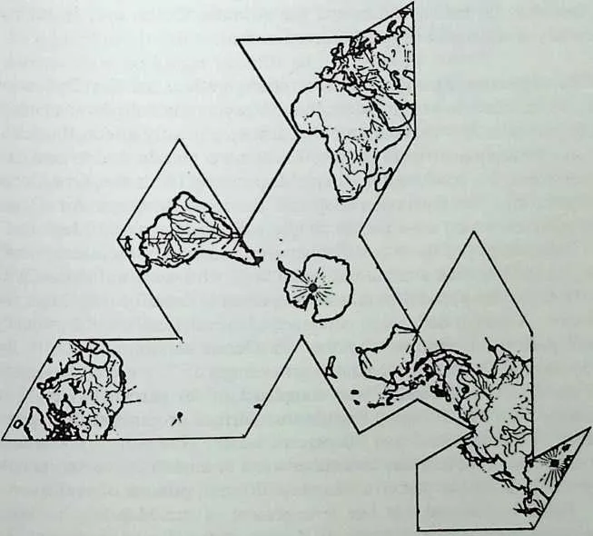
10 Fig. 11-1 The One-Ocean World version of the Dymaxion Map uses the South Pole as its center.
11 which were positioned in the center, and with that knowledge, he set about devising unique arrangements of the Map for specific purposes.10
12 For example, he laid it out in the ‘‘One-Ocean World’’ configuration for use by sailors and those involved in traveling the oceans. That arrange-ment centrally positions the Earth’s oceans, which constitute the majority of the Southern Hemisphere, and relegates the shorelines, which provide navigational markings for sailors, to the outer sections. With Antarctica in the center of the One-Ocean World configuration, land becomes a border for the Earth’s vast water area.11
13 The ‘‘One-Ocean World’’ Map graphically displays many charac-teristics which frequently go unnoticed. For instance, it clearly portrays the vastness of the Pacific Ocean and emphasizes the fact that its longest axis does not run north and south as most people believe, but extends from Alaska’s Aleutian Islands southeast to Cape Hom on the southern tip of South America. The One-Ocean World arrangement also vividly displays the fact that the Indian Ocean and the Atlantic Ocean are, in reality, secondary sections of a single immense ocean.
14 In experimenting with different configurations of the Dymaxion Map, Fuller came to better understand the psychological power of maps and in particular how the common Mercator map greatly affects the think-ing and perception of most people.12 To more clearly understand that phenomenon, he conducted a simple experiment with the One-Ocean arrangement of the Dymaxion Map and the more common Air-Ocean configuration, which most people simply call the Dymaxion Map.
15 Fuller displayed those two distinct arrangements of the same twenty triangles for less than a minute to individuals who were unfamiliar with the Dymaxion Map, and then asked each person to describe what he or she had seen. Although both Maps contained identical sections, the majority of the participants reported that the Air-Ocean version (i.e., with the landmasses in the center) contained an average of 75 percent land, and that the One-Ocean version was composed of 90 percent water.13 In actuality, both Maps display Earth’s true surface proportion of approx-imately 30 percent land and 70 percent water. However, by a simple rearrangment of the sections with either water or land in the center, people were easily misled to perceive two very different notions of reality.
16 Fuller understood that one arrangement of the Map was no more significant than another but merely displayed a different viewpoint. He also realized that the Map’s transformability was an important feature because it allowed any individual to create a configuration in which the geographical location identified as the person’s ‘‘home’’ was centrally positioned.14 With a center triangle displaying the familiar ‘‘home,’’ the Map seems more ordinary and familiar, so an observer is less likely to object to its radical appearance. Once such a tolerance has been estab-lished, motivating a person to consider shifting the sections and examin-ing the Earth from another perspective becomes a much smoother process.
17 Because the Dymaxion Map can be presented in this less intimidating manner, Fuller felt it was a valuable tool for assisting people in attaining the global perspective so vital to our expansive modem society.15 Rather than invalidating people’s experience by proving their previous perception of Earth to be wrong, Bucky and his Dymaxion Map provided a method of first corroborating an individual’s experience and then demonstrating the feasibility of other possibilities. Bucky believed his strategy would be effective because it gently eased individuals away from the dogma of tradition. He understood that every human being is deeply conditioned by the limited perspective of his or her heritage and education but that such a narrow view no longer benefits an individual or society.16
18 Fuller found that by positioning different continents and nations in the center of the Dymaxion Map and examining relationships, individuals could also begin to understand the motivation and the logic behind the actions of individuals and national leaders in ‘‘foreign’’ countries.17 Al-though any size of Dymaxion Map will suffice for seeking such insight, larger Maps provide the most intimate geographic details of the events and beliefs which most influence ail the travelers on Spaceship Earth. Such information and insight are crucial to the personal understanding which Fuller felt each of us must achieve if we are to successfully survive the technologically induced movement of individuals into more intimate con-tact with our Earthly neighbors.18
19 For example, with Australia in the center of the Dymaxion Map, an observer can begin to appreciate just why the inhabitants of that country remain rather isolated despite the advent of high-speed modem transporta-tion and communication. Examining the geographic perspective of other societies provides people with a graphic experience of the influence of location on a culture and a better understanding of exactly where other people are ‘‘coming from’’ as the human species advances toward a unified global society.
20 Fuller himself gained great insight into solving several global issues by examining different arrangements of the Dymaxion Map in great de-tail. He also found that in gaining new perspectives, he developed a stronger compassion for the conditions experienced by his fellow beings around the World.19
21 Because the Earth’s surface is nearly three-quarters water, Fuller felt that one of the most significant World perspectives has always been that of the sailor-navigator, and the Dymaxion Map is the first map to accurately display that view of the entire globe on a single sheet.20 A sailor examines maps from the perspective of being at the center of the surface of a water-covered sphere. He or she views the entire Planet as blanketed by a single ocean, 30 percent of which has peaks tall enough to crop up through the ocean’s surface. Although most people perceive those outcroppings as the land on which we humans live, the sailor-navigator regards them as high mountains around which to guide his or her ship.
22 Such a reckoning of the Earth’s surface may appear strange, but Fuller felt that understanding it was important because it provides another interpretation and that, like all interpretations, it presents unique insights. Through his examination of history, Bucky found that the sailor’s per-spective has been especially beneficial to cultures in which humans have sought new territories that could be reached only via water routes. His Dymaxion Map permits any person to easily display and view features of the Earth’s environment which have been understood and utilized by sailors and navigators for thousands of years, yet that remain relatively obscure to most people.21 Fundamental among the characteristics Fuller himself examined are the movement and influence of the Earth’s water and air atmosphere.22
23 The Earth spins in an easterly direction and influences all the atmo-sphere’s water and air to travel in that same direction. Since water and air are more fluid than solid land, they move much faster, and the momentum generated is greater near the poles, where fewer landmasses obstruct rapidly moving air and water. Every location on Earth makes one revolu-tion each day, but the distance traveled at the equator is much greater than that closer to the poles. Consequently, equator locations move much faster, in terms of distance traveled over a specific amount of time, than elsewhere. That relative speed decreases proportionally as the distance from the equator increases, and it reaches the extreme of no spinning motion at the poles.
24 Although the rapidly traveling atmospheres (water and air) at the equator produce enormous momentum, they do not rival the speed of atmospheres near the poles because of the equator’s land obstructions. When eastbound equatorial water and air strike slower moving land-masses, the collision produces swirling eddies which spiral in the direc-tion of least resistance, toward the poles.
25 That same phenomenon also occurs near the poles, but with less frequency because of fewer obstructions in those regions. When the polar air and water do strike a land obstruction, they also spiral in the direction of least resistance, toward the equator.
26 Bucky discovered that the combination of these two fundamental phenomena produces most of Earth’s weather patterns and storms. He also concluded that storms generally arise over water when the fast-moving air traveling east strikes the western coast of landmasses and its momentum is redirected westward. Following that shift, the traveling air encounters the continuing momentum of other air currents carried with the Earth’s east-erly spin, thereby producing storms.23
27 The phenomena of moving air and water have been known to and used by sailors for thousands of years. In studying ancient marine cultures, Fuller found that early sailing societies realized that the Earth’s movement and changes result from natural forces which can be analyzed, charted, and exploited. He also found that modem ‘‘sailors of the air’’ were examining and charting the Earth’s volatile air and water environ-ments just as their nautical predecessors had done for centuries.24
28 Until recently, neither group of global navigators possessed the means of accurately charting its findings on a comprehensive World map. Fuller’s Dymaxion Map resolved that issue by providing a framework for accurately plotting global patterns of both air and water currents as well as a means of uncovering new discoveries predicated upon those patterns.
29 One such discovery of modem air adventurers is that the same forces which move the Earth, its water, and its lower level air environments produce rapid air currents at higher elevations. Because they encounter fewer land obstructions, high-elevation currents are much stronger than ones nearer the Earth’s surface. Knowledge of that phenomenon has al-lowed pilots to save fuel and travel eastward far more rapidly by ascend-ing to higher elevations and taking advantage of prevailing wind currents.
30 From his examination of global patterns, Fuller discovered that high-elevation currents afford the greatest benefit around the polar regions where winds are rarely obstructed by landmasses.25 For example, travel-ing by jet from northern Russia to Alaska requires only one third the time required for traveling in the opposite direction. Furthermore, the flying time from Alaska to Russia is usually much shorter when a plane follows the longer-distance easterly route via Greenland. It is also generally quick-er to fly on an easterly route from Norway to Minnesota via Siberia and Alaska than to take the seemingly ‘‘direct’’ westerly route.26
31 Less than a century ago, such information was speculative and of little relevance to practical issues; however, it is now as important as the railroad schedule was at the turn of the century. Still, invisible atmospher-ic conditions and major new air-travel routes cannot be accurately dis-played on conventional World maps. They can, however, be precisely exhibited on the Dymaxion Map.
32 Fuller felt that the Dymaxion Map and the polar air routes are even more meaningful in light of the potential for destruction which modem intercontinental nuclear missiles possess. Conventional maps portray Rus-sia and the United States as being separated by enormous distance, but the Dymaxion Map vividly illustrates the proximity of the two countries. Using it, an individual can clearly see that the superpower enemies are actually neighbors separated only by short polar travel routes which can be traversed in a matter of minutes by modem missiles and aircraft.27
33 One of Bucky’s earliest and most controversial global discoveries was his theory that humanity has perennially migrated in a northwestern direction since human beings first walked the Earth.28 Fuller initially detected that migration when he began plotting historical population cen-ters on globes and the Dymaxion Map and found that humanity’s major population centers have continually advanced along a northwest path orig-inating in the South Pacific islands.2^
34 Fuller believed that migration began in earnest when early maritime cultures learned to sail westward into the wind, and then he conjured up the following hypothesis.30 Since human migration began, the dominant flow has followed the Sun on its mysterious westward journey. After that major movement reached Europe, it continued northwest to North Amer-ica rather than southwest to South America.31 Bucky uncovered a plausi-ble explanation for that trend by studying multicolored versions of the Dymaxion Map. His explanation is still discernible on his most recent multicolored Map rendition, on which the colors delineate average yearly low temperature and the border between green and yellow areas represents the ‘‘freezing line.’’ Along that edge, the average yearly low temperature is thirty-two degrees Fahrenheit, the point at which water freezes.
35 North of the freezing line, a person without proper clothing, shelter, and food would most likely freeze to death during the winter. Yet, if early settlers were to stray too far south of that line, they would be without ice, which was often stored underground and proved vital to food preservation during the summer. Remaining as near as possible to the freezing line also proved beneficial in that diseases tended to be less prevalent in colder regions. That advantage was, however, counterbalanced by the fact that a person roaming too far into the colder northern region was susceptible to sudden death from winter storms. In other words, living directly on the freezing line provided the best possible environment for human beings who did not possess modem climate-controlling artifacts. Hence, west-wardly migrating pioneers seldom erected major settlements far from that boundary. This was particularly true during the early evolution of the human species, when clothing had not yet been developed and most people roamed naked or nearly naked.32
36 By carefully plotting data on his map, Fuller determined that human-ity’s northwest migration followed the thirty-two-degree freezing line from the South Pacific, across Asia and India, and into Europe. That migration pattern continued to advance into the United States where, since 1790, it has been formally documented through accurate census records.33
37 In studying the American aspect of global human migration, Fuller found that the first census and all those following it provide clear records of the way in which America’s advancing population followed the thirty-two-degree freezing line. At the time of the initial census in 1790, the center of American population was concentrated near Philadelphia, and it advanced slightly south and west along the freezing line until the Civil War. The first noticeable deviation from that migration along the thirty-two-degree border occurred in 1851, when the center of America’s popu-lation shifted from slightly south of the line to slightly north of it.
38 That incident coincided with the introduction of mass-produced steel and the flourishing of the industrial revolution in the United States. With those innovations, humanity, and Americans in particular, entered an era of transformation from an agrarian to an industrial society. At that time, scientists and engineers began developing inventions which permit-ted environments to be controlled by humans and which created year- round comfort in the most inhospitable climates. For example, practical structural steel permitted the construction of larger and larger buildings which could be created only by use of the steel skeletons that eventually resulted in skyscrapers. As architects designed larger structures employing steel frameworks, engineers began discovering how to heat those build-ings with another new invention, central heating. With the advent of such innovations, people could move north of the freezing line without fear of being at the mercy of the elements. Still, the general flow of human migration continued to follow the northwestern advance which had origi-nated centuries earlier.
39 When Bucky recounted his theory of human migration to his friend Henry Luce during the late 1930s, he also explained that global power centers had followed the population centers along the northwestern route. As a strong advocate of the British Empire’s war effort in the United States, Luce was particularly interested in how such a migration had affected England, and Fuller explained that the British Empire, which Fuller regarded as a front for British economic interests, had also ex-panded along that northwest course.34 Using available data, the Dymax-ion Map, and his understanding of large-scale patterns, Fuller predicted that the economic hub of the British Empire would soon follow global migration patterns and move into North America. He also suggested that the logical site for such a new center was Canada.35
40 At that time, the sophisticated Henry Luce considered Fuller’s pre-diction to be an unfounded but interesting observation. After all, Luce was in constant communication with top British government and business officers, and he knew nothing of such a shift. Yet, just six months later, Fuller received a note from Luce describing how the British government had shipped their secret archives to Ottawa, Canada. Those archives contained major components of the British economy, and Luce acknowl-edged Fuller’s prediction of shifting power as having been correct. He did, however, moderate his recognition of Bucky’s theory by arguing that the move was related not to the migration of economic power, but to a need for additional security as a result of World War II.36
41 Being a person who presented only the complete truth as he per-ceived it at a given moment, Fuller responded to Luce’s note by saying that, like most people, he was aware of the security problems resulting from World War II, but that those factors had not influenced his predic-tion. Bucky explained that he felt that the apparently significant events of any given moment, which most people believed dictate human action, are,-in fact, rarely the motivational force, and that in the majority of instances, the actual cause of a specific event can be perceived only within the context of major patterns.37
42 The migration of humanity over the course of thousands of years is such a pattern, and it constituted the foundation of Bucky’s prediction. He understood that most minor events, which are perceived as significant when they occur and lead to major events such as the transfer of the secret archives, are almost impossible to predict with certainty. Large patterns such as human migration are far more obvious, and when perceived, they support an individual’s understanding and prognostication of lesser cir-cumstances and phenomena.38 Because the Dymaxion Map does not pre-sent great distortions like the conventional Mercator map, many large-scale patterns are far more evident when displayed on it.
43 Prior to the advent of air travel, water was the primary mode of global human transportation and communication. At that time, the Mer-cator map adequately displayed a ‘‘sailing-ship World’’ in which the majority of goods, individuals, and long-distance communications were transported via sailing ship. The primary directions of the lengthy voyages those ships made were east and west. Within that environment, the limited number of cities with good harbors became the most important locations, and the primary routes of commerce extended east or west from those ports.
44 While examining history, Fuller found that in America, New York had the best natural harbor on the East Coast. Consequently, it prospered to become the largest city. Philadelphia and Boston also had good har-bors, but because theirs were not as large as New York’s, those cities did not develop to the size of New York. Still, any port city enjoyed a tremendous advantage over inland locations, which had to rely solely on slower, more costly modes of transportation and communication such as the horse and wagon.39
45 If a town was fortunate, it was blessed with a connection to the ‘‘ships of the land,’’ railways, but few cities had such connections. Wher-ever a railroad station was erected, a new city sprouted and grew, just as was the case with ocean ports. In fact, Fuller felt that the growth of the American railway system had simply been a continuation of the large-scale patterns of human migration.40 Railroads were generally constructed along east and west routes, and because they were designed to serve the areas populated by the most people, ±ey also tended to follow humanity’s northwestern migration route along the freezing line.
46 The settling of the ‘‘Wild West’’ and the expansion of the railroad system provided Fuller with other examples of individuals believing they were operating with some sort of divinely ordained free will while, in fact, they were merely following a large-scale pattern initiated thousands of years earlier. Certainly, each individual has the right to make choices, but Fuller believed that those choices would be much more successful if they conformed to large-scale patterns.41 The Dymaxion Map provides indi-viduals with a tool for exploring and understanding many of those patterns so that they may also learn to operate in greater harmony with other individuals, the environment, and all Universe.
47 Fuller’s work with globes and the Dymaxion Map provided him with a uniquely intimate appreciation of the Earth’s geography and humanity’s relationship to the Planet. Because he so clearly documented that perspec-tive, his work also offers each of us, as well a future generations, insights which could support the discovery of critical solutions to global problems. Bucky appreciated the significance of the fact that 85 percent of the 30 percent of the Earth’s surface covered by dry land is north of the equator and that nearly 90 percent of Earth’s inhabitants reside north of the equa-tor. He utilized those figures to conclude that global humanity is, in fact, concentrated in the Northern Hemisphere and that the Southern Hemi-sphere is predominantly water.42 To better examine and understand the significance of that fact, Fuller developed the ‘‘One-Ocean’’ rendition of the Dymaxion Map shown in Fig. 11-1. With the South Pole positioned in the center of that arrangement, he studied the Planet’s great oceans in their true form, as a single interconnected body of water.
48 He found that most maps portray the World’s oceans as isolated entities and came to feel that such interpretations encourage beliefs which contradict inborn human instincts. After years of examination and person-al experience, Bucky arrived at the conclusion that human beings, and especially young children, have an innate feeling for the fluid wholeness of liquids.43 People naturally understand that all the water within a con-tainer is connected regardless of the size or shape of that vessel, and that the Earth’s surface is in actuality a single area covered with water. In some locations the bedrock beneath our Planet’s water juts above the surface to create ‘‘land,’’ but all the Earth’s oceans actually constitute a single interconnected whole, just as is true of water in a container.
49 Through study, Fuller found that humanity’s maps and educational systems indoctrinate individuals into erroneously believing oceans are separate, isolated entities. However, with the One-Ocean arrangement of the Dymaxion Map, Bucky clearly established and demonstrated the real-ity of Earth’s integrated system of water in a convincing, undistorted display available to everyone.
50 In his examination of history, Fuller had discovered that the most advanced societies have always utilized the Earth’s natural currents for commerce, and that the majority of that trading has been inextricably linked to the World’s oceans.44 He also found that national leaders have invariably succeeded in convincing their citizens that those oceans, like nations themselves, are divided into isolated entities. By focusing on such a divisive strategy, leaders could maintain a ‘‘divide-and-conquer’’ men-tality among their people, could assert the need for continued war with neighboring nations, could maintain a national pride, and, accordingly, could remain in power.45
51 After some study, Fuller came to understand that although humans relish the idea that they have the power to divide land and water masses arbitrarily and to possess small parcels, from a cosmic perspective such apportioning is absurd. He discovered that early in their history, sailing cultures had envisioned the fallacy of such isolationist beliefs and had initiated an ongoing tradition of unbounded global travel, linking them-selves with their fellow human beings by water.46 Bucky found that marine cultures had been freely sailing between locations on the unbroken highway of the World’s oceans for thousands of years; however, in the last centuries, sailing cultures had, ironically, educated their children using the same Mercator map used by land-based cultures.47
52 Fuller discovered that because of such conditioning, the secrets of the Water-Ocean World (i.e., Earth during the period when most commerce and travel was conducted over water routes) were known only to a few individuals. Those people were the ones who regularly traveled the seas and the leaders who exploited nautical secrets for greater wealth. As leaders, they had acquired the clandestine knowledge of the sea from their ancestors, who had passed information and power onto their children as a royal or noble heritage. That secret understanding of the sea is ex-emplified in knowledge about the primary interconnecting waterways of the extreme Southern Hemisphere, which were essential to the control of trade, and therefore wealth, throughout the Water-Ocean World.48 Even today, those routes are not visible on the Mercator map because the South Polar regions are not clearly displayed.
53 Individuals and nations with knowledge of the southerly trade routes became even wealthier by transporting goods from areas of inexpensive abundance to locations where the items were scarce. In that way, inexpen-sive commodities were transformed into rare, extremely expensive goods during a single voyage. Bucky concluded that such exploitation of the distance and isolation between groups of people had been a common practice among human beings since the dawn of humanity. He saw that such a pattern recurring over and over again, dominating cultures until the last few decades and, in some instances, continuing to persist.49
54 In every instance he examined, a small group of people had pur-posefully exploited the remoteness of most people from one another by controlling the majority of trade. Fuller believed that such a process, although seemingly unsupportive of humanity, had inadvertently assisted the development of human cultures. For example, Bucky discovered that during the domination of the sea by the British Empire, metals were transported to England from around the World.50 In England, the metals were combined to produce crude alloys for use in items as varied as weapons and household utensils. To reach England, most of those metals were shipped great distances using the secret trade routes which employed the strong currents flowing eastward around the Antarctic.
55 Those Antarctic routes constituted a surreptitious superhighway of the seas, and they were available to any ship which could withstand the turbulent conditions created by tenacious currents, numerous storms, and a frigid climate. Still, the Antarctic routes remained fairly well concealed because the people who knew of them were aware that any ship sent into the Antarctic currents had to be extremely sturdy or it would not return. Because of that problem, powerful leaders had exceptionally stalwart ships constructed for Antarctic travel. Less well-constructed ships which attempted such a passage usually turned back and reported that the Ant-arctic routes were impassible. As a result, only a small armada of ships was able to exploit the most efficient means of commerce between distant ports for most of human history. Bucky felt that since sailing had become commercially viable, the secret of the Antarctic passage had been a signif-icant economic asset which was guarded by any nation or individual possessing it.51
56 Great Britain had been the last country to control that route and, therefore, the Water-Ocean World. Following World War I, global air transportation began to unfold, and by the onset of World War II, air transport had become a major factor in World domination and transit. With the advent of the modem airplane and regularly scheduled flights along an infinite number of routes following World War II, individuals were no longer restricted to water routes and the domination of those who controlled the seas. Instead, a growing number of individuals were now free to travel to almost any location on Earth whenever they chose.
57 Bucky discovered that although the port cities which had grown into the major centers of population and commerce during the past few cen-turies still retained a cultural and economic prominence, their prosperity was no longer ensured by location. Instead, those cities were finding themselves in competition for dominance as global hubs of activity with more obscure, inland locations.52 With the advent of the airplane, the most efficient trade and commerce routes began shifting from the east-west sea-lanes to the most geographically direct route between two sites, and the significance of sites joined by air networks was not necessarily their location. Fuller found that in the new era of air transportation, any city or nation could compete for prominence as a global nerve center, and that the ones which grew in population tended to become dominant. However, he also speculated that as individuals became increasingly au-tonomous in all areas including thought, economic considerations, and housing, they would feel less and less compelled to live in large cities. By examining census data he found that with the coming of such changes, the
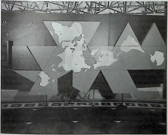
5960Fig. 11-2 A large Dymaxion Map displayed as part of a 1973 traveling exhibition.
61 dominant population centers were shifting from seaports to locations along major flight paths, and he felt that that trend would continue.53
62 From Fuller’s perspective, such sites will become even more signifi-cant in the future as airplane flight paths invariably follow the shortest distance between locations. In our Northern Hemisphere-oriented global society, the majority of those air routes will be established over the North Polar area, causing locations in Canada, Greenland, and Russia to become far more important than ever before.
63 That newly emerging north-south travel orientation and commerce is extremely evident on the most common arrangement of the Dymaxion Map. That version, which Fuller called the Air-Ocean or Spaceship Earth arrangement, is generally referred to simply as the Dymaxion Map, and it displays all the Earth’s landmasses in the central triangular areas with no breaks in continents or visible distortion in size or relationship to one another. It also reveals the efficient north-south North Polar travel routes, which are not visible on most World maps.
64 Bucky witnessed that north-south Earth orientation becoming in-creasingly important as air travel grew during the 1950s and 1960s, and he was quick to note the significance demonstrated by a 1961 transportation event which went virtually unnoticed by the general public.54 At that time, three jet airplanes transported more passengers across the Atlantic than a single passage of the ocean liner Queen Mary in a fraction of the time and far more economically. Because they were not at the mercy of ocean currents and conditions, those airplanes traveled along a more direct, northerly route than the one utilized by ships of the sea.
65 Fuller was one of the first to predict that with the inception of practical ocean passage by planes, sailing ships would become obsolete as an efficient means of human transportation.55 Certainly, people continue to take leisurely cruises on ships, but he foresaw the jet plane replacing all other means of transportation for traveling between two locations as expe-ditiously as possible.
66 Bucky felt that the rapidly increasing transformation occurring within all areas of society was far more significant than most people realized. He frequently reminded his audiences that the dramatic shift from water to air travel represented another large change not popularly predicted even as recently as World War II. Being a observer of major patterns, he had first prognosticated a global air-transportation network in the late 1920s when he was labeled as a wild dreamer at best.56
67 He also realized that the practical onset of air travel would provide individuals with opportunities to live at almost any location on Earth, and he therefore began developing the ‘‘autonomous dwelling machine’’ which later became the Dymaxion House and further evolved into the development of the geodesic dome.57 Fuller predicted that with such liberty, a great many individuals would elect to reside in rural areas and small remote towns rather than the gigantic cities into which people had migrated in search of work.58 In the Fuller scenario, the shift to smaller, less centralized communities would combine with the growing importance of inland cities and result in the decline of the large port cities.
68 As early as the 1970s, Fuller noted that such deterioration had al-ready begun. He contended that the demise of large port cities such as New York and London was (as it continues to be) generally being obstructed only by the corporate and industrial power brokers with heavy investments in port-city real estate. Bucky felt those individuals were unsuccessfully attempting to obstruct the natural trend of human develop-ment toward a north-south-oriented, yet ultimately omnidirectional, pat-tern of travel. They witnessed business and industry leaving the cities and realized that populations would soon follow suit. Those in power also understood that such a migration would result in declining rather than increasing values for their urban investments, and they were doing (as they still are) everything possible to check the unstoppable shift.59
69 One component of their strategy is an attempt to attract new forms of industry into port cities. Advertising campaigns are constantly being cre-ated to portray large, deteriorating port cities as attractive and to present the appearance that such cities represent exciting sites for vacations and business investment. However, since east-west ports are no longer needed to participate in global business, many corporate executives have found that locating in large port cities such as New York and Philadelphia where real estate is overpriced is not an economically sound decision. Hence, corporations, their employees, and their customers are tending to leave rather than to flock to port cities, reversing the trend of previous generations.
70 Fuller also observed another human reaction to the phenomenon of migration from large cities. Individuals who invest in big-city real estate and realize that their investments will eventually fail, simply pretend that large-scale changes are not occurring.60 Such behavior requires main-taining an illusion that the relationship between humans and their Planet remains static and that humanity continues operating within an east-west environment which is adequately portrayed on common World maps such as the Mercator map. Although that strategy has been successful in the past and the Dymaxion Map has never been massively disseminated to the public on a continuing basis which would provide an important global perspective, Bucky was certain that the natural comprehensive human curiosity could not be impeded forever. He felt that this is especially true of children, who are continually confronted by global issues at earlier and earlier ages, and who, like every individual human being, want to per-ceive and understand their domain of operation as comprehensively as possible.61
71 Because Fuller detected the large-pattern transformation of humanity from a limited east-west global alignment to an omnidirectional, pre-dominantly north-south pattern of commerce early in his life, he was able to display that shift on the tool which he had utilized to discover the trend: the Dymaxion Map. Thus, the issue of how to visualize our emerging omnidirectional orientation was solved by Bucky before it ever became a problem. Now, each individual need only spend time examining our global environment on the Dymaxion Map to begin truly appreciating humanity’s transforming relationship to the small sphere Bucky called Spaceship Earth.
72 In all his endeavor, Fuller’s basic operating strategy was to con-struct artifacts (i.e., inventions) which solved specific problems and could be examined by the public. During the early years of his life, Bucky had noticed a great many people with ‘‘good ideas’ ’ who never risked action. Later, as he became more well known, Fuller was perpetually accosted by such individuals who, with the best of intentions, wanted to apprise him of their good ideas, and he became even more aware of the fact that everyone has ideas. Bucky had, however, concluded that merely talking about ideas does not support their advancement or the development of individuals and humanity.62
73 In fact, he found that the majority of people do nothing about their good ideas except engage in seemingly endless discussions. During such discussions, those with the good ideas perpetually attest to the value of their concepts and how their ideas would improve the human condition if only other people would abide by their wisdom.63
74 As he had tried out a similar strategy of talking about his good ideas for a short period, Bucky was keenly aware of that methodology and its ineffectiveness. Once he became cognizant of the abundance of good ideas being discussed, Fuller began building models, both full-size and to scale, of his concepts in order to advance them into more functional forms and to demonstrate their practicality. Through that process, he discovered that translating an idea into a practical artifact is an extremely significant step in its development.64
75 Fuller found that once an idea is manifested in a functional configura-tion, it can be examined by others, and only then can it be put to the crucial test: acceptance and use by society. He also learned that such acceptance does not occur overnight in most instances. Rather, an idea, and the physical manifestation of that idea, must progress through a gestation period which might last for months, years, decades, or even centuries. Still, Fuller believed that an idea has first to be manifested in a functional artifact which can be displayed and discussed.65 He also felt that he learned much more from reducing his ideas to such practical solutions and creating artifacts than from anything else which occupied his time.66 The Dymaxion Map and Fuller’s other global viewing inventions provide excellent demonstrations of that strategy in action.
76 Although he had successfully invented the Dymaxion Map, Bucky was not satisfied and sought to develop other such tools. One of the most sensational such ventures was his campaign to build a sophisticated ‘‘min-iature Earth’’ which he named the Geoscope. Because it is fundamentally a Dymaxion Map fabricated upon a geodesic sphere, the Geoscope can be considered a hybrid of the geodesic dome and the Dymaxion Map.
77 Prior to formally designing the Geoscope, Fuller examined cultural patterns and desires to determine if such an invention was needed and would be accepted. Through that study, he determined that at some point in the near future, large-scale global issues would be a much greater priority and that at that time his invention would be perceived as a necessi-ty. Bucky also discovered that throughout history a great many people had worked on developing better tools for displaying and examining the whole of our Planet. In recent times, such insightful individuals and their ideas have become more evident as humanity has become more globally con-scious. World-viewing artifacts invariably appear at large gatherings where historical and futuristic ideas are exhibited and discussed. Evidence of the search for better methods of displaying Earth has been seen at world’s fairs and other cultural expositions, and those displays helped convince Fuller that his global viewing inventions would be appreciated and used.
78 During the last century, several world expositions have, in fact, featured large miniature Earth models and globes, and following Bucky’s invention of the geodesic dome, expositions tended to shift from globes to geodesic domes as focal elements. Domes have been, and still are, promi-nent at EPCOT Center, the 1967 Montreal World’s Fair, and the 1986 Vancouver World’s Fair, among others. Fuller himself envisioned the Geoscope providing a natural melding of the geodesic dome and human-ity’s innate desire to view the whole of Earth. Accordingly, he set about designing that artifact for future generations even though the necessary technology had yet to be invented.
79 The first Geoscope was ingenious yet extremely simple. Bucky fabri-cated it with the help of a group of architectural and engineering students on the roof of the Electrical Engineering Building at Cornell University in 1951.67
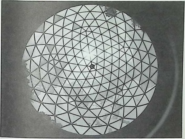
80 The structure’s framework was a geodesic sphere twenty feet in diameter, built of delicate wooden slats painted blue. Since the Earth’s surface is mainly water, Fuller chose blue to provide the Geoscope with a sense of the Planet’s liquidity. The slim blue struts produced a delicate, almost transparent quality similar to that of water. The students who chose to participate in Bucky’s project were each assigned a triangular section of the Dymaxion Map to duplicate on a larger scale for a particular sector of the Geoscope. Each student would painstakingly draw his or her Map
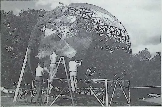
8283Fig. 11-3 Students working on the Cornell Geoscope.
84 section on a large triangular sheet of paper cut to match a Geoscope sector, and those enlarged Map sections were used to outline the Earth’s landmasses on a shiny bronze screen.68
85 The landmass forms were then cut out of the screen and attached to triangular sections of chicken wire corresponding to the triangular open-ings between the wooden slats.69 That process created large triangular chicken-wire-and-bronze Map segments which were fastened to the wood-en slats, thereby creating the first Geoscope.70
86 After weeks of work, Fuller and his student assistants were admiring their representation of the Earth’s surface when they noticed how the sun shining on the Geoscope caused the landmasses to glearn a brilliant gold which vividly contrasted with the blue created by the sky seen through the transparent areas and the blue struts.71 Years later, Bucky was pleased to discover that his brass screen and blue slats were the ideal materials for that presentation when, in 1969, the first photographs of the Earth taken from the Moon were displayed, and they revealed an image very similar to the appearance of that early Geoscope.72
87 The twenty-foot-diameter sphere was aligned with its axis parallel to the Earth’s axis and was supported by three rigid legs atop the roof of the Electrical Engineering Building. Prior to its final installation, the Geo-scope was rotated so that Ithaca, New York (its location), was positioned at the sphere’s highest point.73 In other words, the Geoscope was oriented toward the Earth in the same arrangement as would be a small lifeboat attached to the side of a large ship. In such a situation, the lifeboat is constantly aligned with the position and direction of the ship. Similarly, the Geoscope remained precisely aligned with the Earth. If the ship were to tilt in one direction, the lifeboat would react with an identical maneu-ver, and that phenomenon was also true of the relationship between the miniature Earth Geoscope and the Earth itself.74
88 The result of that phenomenon was accurate observation and a unique perspective. A person seated in the lifeboat would experience the same relationship between the lifeboat and its environment as was felt on the much larger ship; however, the smaller lifeboat would provide a frame of reference which was much easier for an individual to comprehend than that experienced on the gigantic ship. A person in the lifeboat could see the entire boat and its relationship to the larger environment; however, when standing on the deck of a huge ocean liner, the ship’s immense size would prevent such a comprehensive perspective. Still, the orientation would be identical in both vessels.75
89 That same phenomenon occurred with the Geoscope. It provided a precise representation of Earth and its relationship to the rest of the com-ponents of the cosmos, which could be intimately examined and experi-enced by individuals. To create an even more vivid experience of that relationship, Fuller and his team constructed a viewing platform within the sphere. They attached a ladder to one of the tripod legs so that an individual could climb onto the interior platform. The team also built a chin rest above the platform so an observer could easily position his or her head in the exact center of the sphere and experience a view corresponding to one from the center of the Earth. That viewpoint afforded an oppor-tunity to look out through the Earth’s landmasses as well as to observe their true relationship to one another and to the visible celestial bodies.76
90 The fact that the Earth’s center was be four thousand miles from the observer would seem to impede an accurate view of those relationships. However, Fuller realized that when compared to the nearest star being examined (i.e., the sun at ninety-two million miles from the Earth), the distance between the Earth’s center and the Geoscope would become insignificant and that in relationship to more distant stars and galaxies, that four thousand miles would become even more inconsequential.
91 To clarify that phenomenon further Fuller explained that if the light radiating from the Earth were visible in the nearest galaxy, an observer at that location would not be able to distinguish the distance between the Geoscope and the Earth’s center. In other words, because of its tiny size relative to other celestial bodies, anyone observing Earth from the dis-tance at which Fuller and his team were observing other celestial bodies would find it impossible to distinguish the Geoscope from the Earth itself. Since that phenomenon would also apply to observations made in the opposite direction, the view from the Geoscope could, for all practical purposes, be considered identical to that from the center of the Earth.77
92 Asserting their natural curiosity, Cornell science and engineering students began using the Geoscope to make astronomical observations and calculations, such as the positions of stars at specific times, and compared their readings with those of local observatories. They found their Geo-scope observations to be extremely accurate, once again validating Full-er’s contention that the four-thousand-mile distance between the Earth’s center, which is the true observation point for such calculations, and the Geoscope was insignificant.78
93 Students also relished viewing the night sky from the Geoscope’s underside. They would lie with their heads below the Geoscope looking directly from the South Pole to the North Pole and would be amazed to observe the North Star directly above the Geoscope’s North Pole. Some students were so eager to work with the Geoscope that they occupied the center viewing post for hours on end and were able to see the North Star apparently fixed in the same position above the North Pole while other stars seemed to move in relationship to the Geoscope’s grid of slats and mesh. Those students also discovered that the closer stars appeared to the Earth’s equator, the more rapidly they seemed to move past the grids of the Geoscope.79
94 Fuller explained that although their experiential observations were correct, their interpretation of the phenomenon was not. He reminded his students that the movement they had witnessed was not that of the stars but the movement of the Earth itself and primarily the Earth’s rotation. Once the students grasped that simple fact, they began to realize they were, in fact, experiencing the spinning motion of our Planet.80 Fuller himself speculated that the Geoscope may have provided human beings with their first experience of actually ‘‘feeling’’ the Earth’s rotation.81
95 Students were so fascinated with the Geoscope that many clear eve-nings would find groups making observations until dawn. Bucky also loved to spend time with the Geoscope, and he found that because it was not solid, the bronze mesh used to form the landmasses caught light from the stars, providing a particularly beautiful vision. The Geoscope’s com-bination of elements produced an amazingly true sense of stars glistening against the landmasses, and people were constantly stopping by to view the sky through it.82
96 Unfortunately, that same curious attraction also led to the Geo-scope’s demise. Being a sturdy geodesic sphere, the Geoscope survived New York State’s weather quite well on the roof of that building. It was, however, not immune to human intervention, and one Halloween a group of mischievous students decided to try rolling the popular attraction around the campus. They reached the rooftop Geoscope only to discover that because the components had been assembled on the roof, it would not fit through the doors. Consequently, the pranksters hastily decided to transport the Geoscope by the most direct means available, pushing it over the side of the building. As it was a fragile structure designed for station-ary use, that original Geoscope could not withstand abuse, much less a fall from several stories, and it was reduced to a pile of rubble on the lawn of the Cornell Electrical Engineering Building that night.83
97 Undaunted by the destruction of the Cornell artifact, Bucky con-tinued developing other, more sophisticated Geoscopes. During 1970, he designed and supervised construction of the largest of those artifacts at
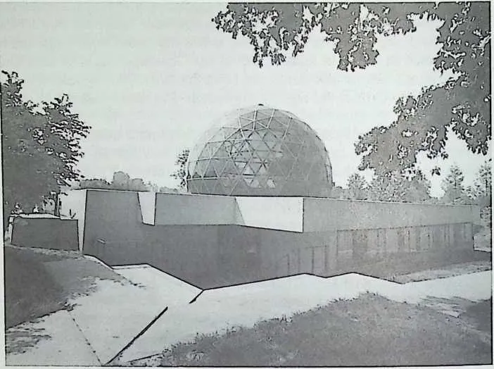
99100Fig. 11-4 An exterior view of the Southern Illinois University Geoscope.
101 Southern Illinois University in Edwardsville. At the time, Bucky was serving as Distinguished University Professor at SIU, and a consortium of religious organizations combined their resources to commission his ser-vices in designing a portion of their new, centralized religious-activities building. Bucky’s contribution was a fifty-foot-diameter Geoscope which also serves as the building’s auditorium.84
102 As with other Geoscopes, an individual enters into the structure to outwardly observe Universe. Fuller found that when a person arrives at the center of a Geoscope and begins to look out, he or she is immediately overcome with the sensation of being thrust outward into Universe.85 Thus, the Geoscope models one of Universe’s great paradoxes: An indi-vidual turns inward to expand outward.
103 Gradually, cosmic-observation Geoscopes such as those erected at Cornell and Edwardsville were displaced in Fuller’s work by what he considered a far more useful configuration of the device. Following his experience at Cornell, Bucky spent three years working part time on a
105106Fig. 11-5 Looking up at the interior of the SIU Geoscope.
107 two-hundred-foot-diameter Geoscope at the University of Minnesota.86 He was extremely dedicated to that effort because he felt that that in-vention would revolutionize humanity’s perception of our Planet and would be of enormous benefit to human development.
108 Rather than an instrument for looking outward at the cosmos, Full-er’s new concept of the Geoscope was as a tool for individuals to observe Earth and the relationships between human beings and our Planet. During the period from 1954 through 1956, he and a group of Minnesota students were able to complete a portion of the massive two-hundred-foot-diameter geodesic sphere which was to serve as the structure of his new miniature Earth Geoscope.87 It was also during that period that Bucky initiated a campaign advocating the construction of a two-hundred-foot-diameter miniature Earth Geoscope in New York City directly across from the United Nations. His choice of the two-hundred-foot-dimension was not arbitrary. The new version of the Geoscope was specifically designed to display the entire Earth at a scale which would allow people to identify with details as tiny as individual houses and thus to perceive the rela-tionship between their homes---and therefore themselves---and the entire Planet.88
109 One news event also influenced Bucky’s choice of size and scale. At the time, the United States Air Force was in the process of surveying the Earth’s landmasses using newly developed aerial techniques in conjunc-tion with motion-picture cameras. The scale of the U.S. Air Force’s lowest level and most detailed flight photographs was 1 to 200,000, or one inch equaling approximately three miles. At that scale, the entire Planet can be portrayed as a sphere approximately two hundred feet in diameter. Because that scale was already being used to create a mapping system which could eventually be employed to provide the Geoscope with even better accuracy, and because that scale furnished observers with a work-able view of their relationship to the entire Planet, Fuller adapted the same l-to-200,000 scale for his Geoscope.89
110 At that scale, the City of Los Angeles is 1 '/z feet in diameter, and a town of five thousand people emerges as a circle approximately 1 inch in diameter. An acre of land is */64 inch square (i.e., roughly the smallest detail recognizable with the naked eye), and an average house, although minute, is represented as a speck */ioo inch in diameter. Bucky realized that people would not be able to see their homes on such a Geoscope without standing next to the exact location and using a magnifying glass. They could, however, recognize their town and perhaps their sector of a city from a short distance away, and that possibility was to provide a more intimate relationship between the observer and the Geoscope, even though it was, in reality, designed to be viewed from a distance of approximately one thousand feet.90
111 From such a vantage point, an observer’s town would be visible, and an individual could realistically claim that although his or her house could not be seen, it was an actual speck which could be found with powerful binoculars. Thus, every person could have a sense of belonging on Space-ship Earth.91
112 As with so many of his inventions, Fuller’s Geoscope idea of the 1950s was designed to utilize technology which he had forecast but which had yet to be invented. He envisioned the structure as being covered with either colossal rounded televisions or, more realistically, a massive number of tiny, computer-controlled lights. Those miniature lights could be instantaneously changed in color and intensity to produce the ap-pearance of a single image, just as is now done on the stadium screens used at major athletic events.
113 The Geoscope was to portray patterns of historical events which occurred over such a long period that humans have never before been able to truly experience or comprehend them in a short time. For example, it could be programmed to display the Earth’s changes over the last four ice ages, which were each on the order of one million years in length. When displayed using intervals of 250,000 years, that entire 5-million-year peri-od of enormous change could be reduced to a comprehensible four-minute presentation. Such a spectacle would provide viewers with a capsule summary of how our Planet’s landmasses were formed as well as some idea as to the relatively short period humans have inhabited Earth.
114 Even more significantly, the large Geoscope would be able to visu-ally display continuously updated information about all aspects of Earth. Conditions such as current population, resource allocation, weather pat-terns, and weaponry deployment could be revealed in an instant to provide observers a firsthand experience of critical global activities which vitally affect the lives of everyone. Bucky believed that by utilizing such a Geoscope, individuals could begin to recognize formerly invisible patterns and could work together in generating unique new strategies far more comprehensive than what had been seriously considered before.92
115 He also felt that the Geoscope could be employed to examine and display strategies for success which he proposed in his World-Game Com-prehensive Anticipatory-Design Science.93 Those strategies could then be programmed into the Geoscope’s computer, just as war games are now programmed into computers, and the future effects on Earth would be instantly visible on the Geoscope. With such a tool, rather than waiting for decades or centuries to learn the harmful or successful consequences of actions, humanity would be provided with immediate visual responses to proposed solutions on a scale that every individual could understand.
116 During the 1950s and 1960s, Fuller advanced that Geoscope closer to reality. He prepared a proposal to erect it in New York City on what was then Blackwell’s Island and is now called Roosevelt Island. That island is just east of the United Nations buildings, and the Geoscope was to hang from a series of nearly invisible cables and masts so that its top would be at the same height as the top of the four-hundred-foot United Nations Secretariat Building. If it were suspended in that manner, almost any delegate looking out his or her window would be constantly confronted by an ever-changing, animated view of our entire Planet and the conse-quences of decisions and actions taking place within the United Nations. For instance, even the slightest armed conflict or military violence was to be instantaneously displayed with glaring red lights, so that everyone would be aware of it. Bucky believed that a continuously changing Geo-scope of that magnitude would provide a perspective of our tiny Planet much different from what is normally available and would inspire people responsible for global decisions to think twice about potential actions.94
117 Fuller’s U.N. Geoscope proposal in no way intimated that he had capitulated to the popular belief that politicians were useful to modem humanity. He felt as strongly as ever that politicians were becoming increasingly obsolete and that they would be totally outmoded by the 1970s. Still, he wanted to confront as many people from different sectors of the Earth as possible with a palpable display of the consequences of humanity’s actions, and the United Nations seemed to be the single site at which to fulfill that desire.95
118 Although Fuller’s dream Geoscope has not yet been constructed, his proposal did receive a favorable reception from a majority of the United Nations representatives. In fact, the Secretary General at the time, U Thant, was so excited by the idea that he hosted a luncheon for United Nations ambassadors from all delegate countries at which Fuller formally presented the Geoscope concept. Thant also advanced the idea on several other occasions, but the United Nations was unable to generate the $10 million that Bucky estimated would be required to complete the project.96 Fuller wanted to see that massive Geoscope erected during his lifetime, but once again, he did not become mired in attempting to complete the project. Instead, he moved on to the next issue which he felt needed his attention, knowing he had initiated another idea that would progress through its gestation period and be available to humanity when it was vitally needed.
119 Since that time, the computers and mechanical technology needed to economically erect such a Geoscope have been invented. The primary obstacle which limits its practical implementation is humanity’s priorities. In other words, how deeply into crisis must we plunge our species and our Planet before we feel forced to produce this sophisticated tool and benefit from the perspective it can provide?
120 Fuller understood that humanity has always operated within a system of semichaos which he often described as emergence by emergency. People invariably put off resolving issues until the ascendance to public visibility of a serious problem which focuses the general population’s attention on that issue. Then, when the issue becomes popular, readily available solutions are sought and it is resolved.97
121 Fuller found that that process occurs with problems as far-reaching as eradicating major diseases and education and as insular as installing streetlights and sewer systems. He discovered that, in most instances, human nature invariably influences people to wait until an issue reaches a critically threatening level before acting upon it, and he felt that the relationship between human beings and Spaceship Earth was rapidly reaching such a level. Bucky believed that our emerging global society needs to take a giant step beyond our ancestors’ survival-oriented struggle against Nature and each other. He saw that that ongoing ‘‘battle’’ had moved us to the brink of annihilation because of its focus on more ad-vanced weaponry rather than on the tools for life support which he chris-tened ‘‘livingry,’’ and he introduced the Geoscope as an example of how technology could support rather than destroy life.98